Ride Results Routes Archive |
||||
|
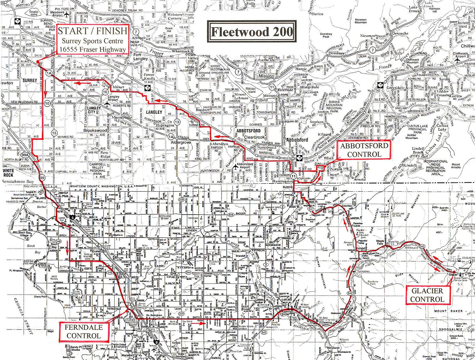
Lower Mainland Spring 200 Saturday, April 12, 7:00 a.m. Start/Finish: Surrey Sports & Leisure Centre 16555 Fraser Highway |
|
|
|
|
|
(km) |
| 0.0 |
Surrey Sports & Leisure Centre (16555 Fraser Highway) |
|||
| 0.3 | L | ESE | Fraser Highway #1A | 0.5 |
| 0.8 | R | S | 168 St | 9.8 |
| 10.6 | R | W | 32 Av | 1.7 |
| 12.4 | L | S | 160 St - Croydon Dr - 20 Av | 3.1 |
| 15.5 | R | S | 164 St | 0.8 |
| 16.3 | R | W | 16 Av | 0.5 |
| 16.8 | L | SE | King George Hwy - #99A | 2.0 |
| 18.8 | SO | S | Access to Hwy #99 to US Customs | 2.2 |
| 21.0 | SO | SW | US Customs, Blaine WA, Peace Portal Dr | 3.5 |
| 24.5 | R | S | Bell Rd - becomes Blaine Rd | 2.5 |
| 27.0 | BL | SE | Loomis Trail Rd | 1.7 |
| 28.7 | R | S | Kickerville Rd | 4.9 |
| 33.6 | L | E | Bay Rd - becomes Vista Dr | 12.5 |
| 46.1 | R | S | Second St - Ferndale WA | 0.6 |
| 46.7 | L | E | Cherry St | 0.2 |
| 46.8 | R |
Pioneer Park |
||
| 46.8 | N | 1st Av | 0.4 | |
| 47.2 | R | E | Main St | 0.3 |
| 47.5 | BR | SE | before underpass - Hovander Rd - cross RR | 1.6 |
| 49.0 | L | E | Smith Rd - cross Hwy I-5 | 19.9 |
| 68.9 | L | NE | Hwy #542 - cross Nooksack river | 1.8 |
| 70.7 | SO | E | #542 joins Hwy #9 | 7.4 |
| 78.1 | BL | NE | Hwy #542 toward Mt Baker | 13.4 |
| 91.4 | BR | E | at Kendall on Hwy #542 | 16.9 |
| 108.3 |
Graham's Restaurant/Store |
|||
| 108.3 | W | Hwy #542 - return | 16.8 | |
| 125.1 | BR | W/N | Hwy #547 - Kendall Hwy | 8.1 |
| 133.2 | SO | NW | Hwy #547 down Reese Hill - CAUTION | 8.0 |
| 141.3 | L | W | becomes Rock Rd, Sumas | 1.2 |
| 142.5 | R | N | Cherry St | 1.1 |
| 143.6 | SO | N | Canadian Customs - Hwy #11 | 0.2 |
| 143.8 | R | E | 2nd Av - Huntingdon BC | 0.8 |
| 144.6 | L | E | Boundary Rd - becomes Whatcom Rd | 3.9 |
| 148.6 | R | E | Vye Rd | 0.8 |
| 149.4 | L | N | Fadden Rd | 0.8 |
| 150.2 | R | E | Nelles Rd | 0.1 |
| 150.3 |
Birchwood Dairy |
|||
| 150.3 | L | W | Nelles Rd | 1.0 |
| 151.3 | L | S | Whatcom Rd | 0.8 |
| 152.1 | R | W | Vye Rd | 3.8 |
| 155.9 | R | N | Riverside Rd | 1.8 |
| 157.7 | L | W | King Rd - up hill | 4.8 |
| 162.5 | SO | W | cont.- King Rd (around hill at Clearbrook Rd) | 1.7 |
| 164.2 | R | N | Townline Rd - becomes S Fraser Way | 3.7 |
| 167.9 | R | N | Mt Lehman Rd | 0.1 |
| 168.0 | L | W | Route #1A - Fraser Hwy | 3.2 |
| 171.3 | R | N | Bradner Rd | 2.0 |
| 173.3 | L | W | Downes Rd | 1.6 |
| 174.9 | R | N | Lefeuvre Rd - becomes Watson Rd | 2.7 |
| 177.6 | R | N | 272 St - becomes 52 Av | 2.1 |
| 179.7 | R | N | 264 St (Hwy #13) | 0.3 |
| 180.0 | L | W | 56 Av | 3.9 |
| 183.9 | SO | W | 56 Av - don't go Left downhill | 0.3 |
| 184.2 | R | N | 244 St - becomes 58 Av | 0.7 |
| 185.0 | R | N | 243 St | 0.6 |
| 185.6 | L | W | 61 Av | 0.6 |
| 186.2 | R | N | 240 St | 0.3 |
| 186.5 | L | W | 62A Cres - becomes 64 Av | 4.8 |
| 191.3 | R | N | 216 St | 0.8 |
| 192.1 | BL | NW |
216 St - Milner - cross Glover Rd + RR becomes Crush Cr |
1.2 |
| 193.4 | BL | W | becomes 72 Av | 6.4 |
| 199.8 | R | WNW | Fraser Highway #1A | 3.4 |
| 203.2 | R | N | 166 St | 0.3 |
| 203.5 |
FINISH - CONGRATULATIONS |
|||
|
|
||||
|
|
||||
| Note: This is not the official route sheet. Ride organizers may make last minute changes because of road closures or other problems. The route sheet you receive at the start of the ride is the official one. | ||||