Fall Flatlander 200 km
September 23, 7 a.m.
Start: Lion's Hall, Glover Rd @ 88th Av.
Finish: Fort Pub, 9273 Glover Road
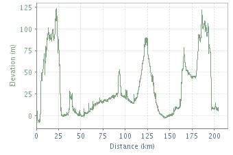
(profile: Roger Holt)
|
Fall Flatlander 200 km September 23, 7 a.m. Start: Lion's Hall, Glover Rd @ 88th Av. Finish: Fort Pub, 9273 Glover Road (profile: Roger Holt) |
|
(cum.) |
|
|
|
|
|
Lion's Hall Glover Rd @ 88th Av. |
||||
| 0.0 | R | E/N | 88th / Hudson Bay | 1 |
| 1.0 | L | W | Mary | 0.1 |
| 1.1 | R | N/W | Royal / Mavis | 0.4 |
| 1.5 | R | NE | River | 1.6 |
| 3.1 | R | S | 240th / 88th / 240th / Rawlinson | 1.3 |
| 4.4 | L | S | 240th | 2.4 |
| 6.8 | L | E | 72nd | 1.7 |
| 8.5 | R | S | 248th | 1.5 |
| 10.0 | L | E | 64th | 3.4 |
| 13.4 | R | S | 264th | 1.6 |
| 15.0 | L | E | 56th | 0.3 |
| 15.3 | R | SE | Gloucester | 1.6 |
| 16.9 | R | S/E | 272nd / Townshipline, Abbotsford | 7 |
| 23.9 | L | N | Mount Lehman | 0.8 |
| 24.7 | R | E | Hawkins | 0.8 |
| 25.5 | R | S/E | Olund / Bates | 2.5 |
| 28.0 | R | E | Townshipline | 5 |
| 33.0 | R | S | Riverside | 0.9 |
| 33.9 | L | E | Clayburn | 0.1 |
| 34.0 | R | S | Route 11 / Gladys | 3.6 |
| 37.6 | SO | S | Cyril | 1.5 |
| 39.1 | BR | SW | Thru Underpass to S.Fraser | 0.1 |
| 39.2 | BR | S | Route 11 | 0.4 |
| 39.6 | L | E | Delair | 2.3 |
| 41.9 | R | SE | Lower Sumas Mtn | 0.5 |
| 42.4 | R | S | North Parallel / Eldridge | 5.8 |
| 48.2 | R | E/N | Atkinson / North Parallel | 4.5 |
| 52.7 | R | E | #3 X Rte 1 O/P | 0.8 |
| 53.5 |
|
|||
| 53.5 | SO | E | #3 | 1.8 |
| 55.3 | L | N | Tolmie | 1.5 |
| 56.8 | R | E/S | #2 / Boundary | 1.3 |
| 58.1 | L | E | Keith Wilson X Vedder Canal, Chilliwack | 1 |
| 59.1 | L | N | Chadsey | 3.1 |
| 62.2 | L | W | Yale Rd West X Rte 1 | 0.8 |
| 63.0 | R | NE | Industrial | 5.3 |
| 68.3 | BL | E | Progress Way | 1.1 |
| 69.4 | L | N | Lickman Rd / Chilliwack Mtn Rd | 1.7 |
| 71.1 | R | NE | Scheyey / Wolfe / Hodgins | 2.8 |
| 73.9 | L | N | Corbould | 1.6 |
| 75.5 | R | E | Berkeley | 0.4 |
| 75.9 | L | N | Young | 0.2 |
| 76.1 | R | E | Hope River | 4.3 |
| 80.4 | R | E | Camp River / Ferry under bridge | 11.1 |
| 91.5 | L | S | Rte 9 | 1.8 |
| 93.3 | R | W | Yale Rd East | 0.3 |
| 93.6 |
|
|||
| 93.6 | SO | W | Yale Rd East | 5.3 |
| 98.9 | L | S/W | Annis / Prairie Central | 7.4 |
| 106.3 | L | S/W | Banford / Linford / Bailey | 6.1 |
| 112.4 | L | S | Chilliwack River | 0.9 |
| 113.3 | R | W | Promontory | 1 |
| 114.3 | L | S | Vedder Rd | 1.6 |
| 115.9 | L | SE | Chilliwack Lake | 7 |
| 122.9 |
|
|||
| 122.9 | T | W | Chilliwack Lake | 7 |
| 129.9 | L | W | Vedder Mtn / Yarrow Central | 9.1 |
| 139.0 | L | S/W | Boundary / Town / Campbell | 5.6 |
| 144.6 | L | S/W | Interprovincial / Wellsline / Faddon | 9.2 |
| 153.8 |
|
|||
| 153.8 | L | W | Nelles | 1 |
| 154.8 | L | S | Whatcom Rd | 0.8 |
| 155.6 | L | E | Vye | 0.2 |
| 155.8 | R | S | Whatcom / Boundary / 2nd., Huntingdon | 4.9 |
| 160.7 | R | N | B | 0.2 |
| 160.9 | L | W | 4th X Rte 11 | 0.5 |
| 161.4 | R | N | Riverside | 0.4 |
| 161.8 | L | W | Farmer | 1.6 |
| 163.4 | R | N | McCallum | 0.8 |
| 164.2 | L | W | Huntingdon | 4.8 |
| 169.0 | L | S/W | Townline / Zero | 10.9 |
| 179.9 | R | N | Route 13 / 264th | 17.8 |
| 197.7 | L | W | 88th / River | 6.3 |
| 204.0 | R | W | Mavis, Fort Langley | 0.2 |
| 204.2 | R | N | Glover Rd X RR | 0.1 |
| 204.3 |
Fort Pub |
|||
| Note: This is not the official route sheet. Ride organizers may make last minute changes because of road closures or other problems. The route sheet you receive at the start of the ride is the official one. | ||||
_