|
Abbotsford-Abbotsford-Abbotsford-Abbotsford- 600 June 3, 6 a.m. Bob Marsh & Patty Marsh (Route #11 - Sumas Way @ Lonzo Ave.) (Route #11 - Sumas Way @ Delair Road [near park & ride]) |
|
(cum.) |
|
|
|
G0 kms |
| 0 | R | E | Lonzo Ave (Park & Ride Parking Lot) | 0.1 |
| 0.1 | R | S | Route #11 -- Sumas Way | 0.6 |
| 0.7 | L | NE | South Parallel Rd. | 12.9 |
| 13.6 | R | E | No.3 Rd. | 2 |
| 15.6 | R | S | Tolmie Rd. | 0.1 |
| 15.7 | L | E | No.3 Rd. | 3 |
| 18.7 | L | E | Yarrow Central Rd./ Vedder Moutain Rd. | 7.8 |
| 26.5 | R | E | Chilliwack Lake Rd. | 20.8 |
| 47.3 |
|
|||
| 47.3 | T | W | Chilliwack Lake Rd. | 20.8 |
| 68.1 | R | NE | Veddar Rd. | 1.7 |
| 69.8 | R | E | Promontory Rd. | 1.1 |
| 70.9 | L | NE | Chilliwack River Rd. | 0.9 |
| 71.8 | R | E | Bailey Rd. | 2.1 |
| 73.9 | B/L | NE | Lindell R.d / Banford Rd. | 4 |
| 77.9 | R | E/N | Prairie Central Rd / Annis Rd.- X TCH | 7.4 |
| 85.3 | R | E | Yale Rd. east - Crossing Route #9 | 7.7 |
| 93 | R | E | Yale Rd. east (@ Popkum Rd. North ) | 1 |
| 94 | R | S | Popkum Rd. X TCH O/P & exit #138 | 0.2 |
| 94.2 | L | E | Route # 1 / TCH (Watch Rumble Strips) | 25.4 |
| 119.6 | B/R | E | Off Ramp @ Exit # 165 | 0.4 |
| 120 | L | NE | Crossing Route # 1 on O/P | 0.2 |
| 120.2 | R | E | Flood - Hope Rd. | 6.5 |
| 126.7 | R | E | Old Hope - Princeton Hwy - Hope | 1 |
| 127.7 |
Cheveron |
|||
| 127.7 | T | W | Old Hope - Princeton Hwy | 1 |
| 128.7 | B/L | W | Flood - Hope Rd. | 6.7 |
| 135.4 | CO | W | Route # 1 / TCH (Watch Rumble Strips) | 25.8 |
| 161.2 | B/R | W | Off Ramp @ Exit #138 | 0.4 |
| 161.6 | R | N | Popkum Rd. | 0.1 |
| 161.7 | L | W | Old Yale Rd. | 0.9 |
| 162.6 | L | SW | Popkum Rd. / Old Yale Rd.east | 16.9 |
| 179.5 |
Tim Hortons @ Williams |
|||
| 179.5 | Co | W | Yale Rd. east - Chilliwack | 0.6 |
| 180.1 | B/L | S | Yale Rd. | 2.2 |
| 182.3 | R | W | Yale Rd. west ( do not cross Route #1) | 3.5 |
| 185.8 | L | S | Lickman Rd. crossing Route #1 O/P | 4.7 |
| 190.5 | R | W | Keith Wilson Rd. crossing Vedder Canal | 5.8 |
| 196.3 | R | N/W | Boundry Rd. / No. 2 Rd. | 2.3 |
| 198.6 | L | S | Interprovincial Hwy | 1.5 |
| 200.1 | R | W | No.3 Rd. X Route #1 O/P | 1.6 |
| 201.7 | L | SW | No. Parallel Rd. / Atkinson Rd. | 4.5 |
| 206.2 | L | SW | Eldridge Rd. / No. Parallel Rd. | 5.8 |
| 212 | L | W | Lower Sumas MTN. Rd. - Was Old Yale Rd. | 0.5 |
| 212.5 | L | W | Delair Rd. X Route #11 | 2.4 |
| 214.9 |
Super 8 Motel |
|||
| 214.9 | L | E | Dleair Rd. | 0.1 |
| 215 | R | S | Route #11 -- Sumas Way | 0.2 |
| 215.2 | R | W/N | Lonzo Ave. / Vedder Way | 0.8 |
| 216 | L | W | Marshall Rd. | 0.1 |
| 216.1 | L | S | Riverside Rd. | 0.6 |
| 216.7 | R | W | King Rd. | 4.7 |
| 221.4 | R | N | Clearbrook Rd. | 0.1 |
| 221.5 | L | W | King Rd. | 1.7 |
| 223.2 | R | N/W | Townline Rd. / So. Fraser Way | 3.8 |
| 227 | R | N | Mount. Lehman Rd. | 0.1 |
| 227.1 | L | W | Route 1A - Fraser Hwy | 20.8 |
| 247.9 | R | N/W | 206 ST. / Logan Ave. Langley | 0.3 |
| 248.2 | R | N | Glover Rd. | 1.1 |
| 249.3 | L | NW | Mufford Cresent / 64th Ave. | 15.7 |
| 265 | L | S | 132 St. Surrey | 1.2 |
| 266.2 | R | W | Route #10 / Ladner Trunk Rd. | 15.8 |
| 282 | L | S/W | Harvest Dr. / 44th Ave. Ladner | 1.7 |
| 283.7 | L | S | Arthur Dr. | 3.2 |
| 286.9 | L | E | 28 th Ave. | 0.6 |
| 287.5 | R | S | 56 th St. | 3.2 |
| 290.7 |
Tim Hortons @ 12th |
|||
| 290.7 | T | N | 56 th St. | 2 |
| 292.7 | R | NE | Route # 17 | 1.6 |
| 294.3 | R | E | 28 th Ave. | 0.8 |
| 295.1 | L | N | 64 th St. | 1.6 |
| 296.7 | R | E | 36 th Ave | 1.6 |
| 298.3 | L | N | 72 nd Ave. | 1.5 |
| 299.8 | R | E | Churchill St. (Boundry Bay Airport) | 1.5 |
| 301.3 | L | N | 80 th St. | 0.8 |
| 302.1 | R | E | Route # 10 - Ladner Trunk Rd. | 11.3 |
| 313.4 | L | N | 132 nd St. | 1.2 |
| 314.6 | R | E | 64 th Ave - Mufford Cresent | 15.7 |
| 330.3 | R | SW | Glover Rd. | 1.1 |
| 331.4 | L | E/S | Logan Ave. / 206 th St. | 0.3 |
| 331.7 | L | SE | Route #1A - Fraser Hwy | 20.8 |
| 352.5 | R | S | Mount Lehman Rd. | 0.1 |
| 325.6 | L | SE | So. Fraser Way - Townline RD. | 3.8 |
| 356.4 | L | E | King Rd. / Clearbrook Rd / King Rd. | 6.5 |
| 362.9 | L | N | Riverside Rd. | 0.6 |
| 363.5 | R | E | Marshall Rd. | 0.1 |
| 363.6 | R | S/E | Vedder Way / Lonzo | 0.8 |
| 364.4 | L | N | Route # 11 - Sumas Way | 0.2 |
| 364.6 | L | W | Delair Rd | 0.1 |
| 364.7 |
Super 8 Motel |
|||
| 364.7 | L | E | Delair Rd | 0.1 |
| 364.8 | L | N | Route #11 - Sumas Way | 0.6 |
| 365.4 | L | NW | So. Fraser Way | 0.1 |
| 365.5 | R | N | Cyril St. / Gladys Ave. / Route #11 | 5.3 |
| 370.8 | L | W | Clayburn Rd. | 0.1 |
| 370.9 | R | N | Riverside Rd. | 0.8 |
| 371.7 | L | E | Townshipline Rd. | 0.5 |
| 372.2 | R | N | Riverside Rd. | 3.1 |
| 375.3 | L | NW | On Ramp to Mission Bridge / Route #11 | 3.4 |
| 378.7 | L | W | Route # 7 - Lougheed Hwy | 21.7 |
| 400.4 |
Maple Ridge Esso, @ 232nd St |
|||
| 400.4 | T | E | Route # 7 - Lougheed Hwy | 22.8 |
| 423.2 | CO. | E | North Railway St. Mission - Route # 7 east | 48 |
| 471.2 | R | E | Route #7 east joins Route #9 South | 1.7 |
| 472.9 | B/L | NE | Route # 7 east - Haig Hwy leaves Route #9 South | 30.4 |
| 503.3 | L | S | Route #1 TCH / Water St - Hope | 3.3 |
| 506.6 | L | E | Old Hope - Princeton Hwy | 1 |
| 507.6 |
Chevron |
|||
| 507.6 | T | W | Old Hope - Princeton Hwy | 1 |
| 508.6 | R | N | Route #1 TCH / Water St - Hope | 3.3 |
| 511.9 | R | SW | Route #7 - Haig Hwy | 28.5 |
| 540.4 | BR | W | Route # 7 - Haig Hwy @ Agassiz | 1.9 |
| 542.3 | BR | NW | Route #7 West joins Route #9 North | 1.7 |
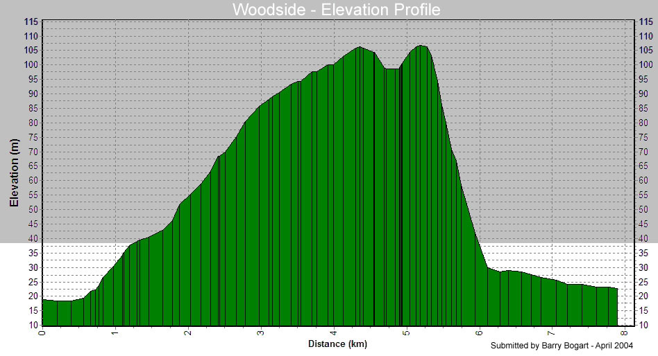
| 544 | L | S/W | Route #7 West -Lougheed Hwy leaves Route #9 North (warning: Woodside) | 47.1 |
| 591.1 |
Tim Hortons, First Ave |
|||
| 591.1 | T | E | First Ave. | 0.2 |
| 591.3 | R | S | Murray St. RR - OP | 0.2 |
| 591.5 | L | S | Home St. | 0.1 |
| 591.6 | R | W | Route #11 - Feeder Rd. | 0.9 |
| 592.5 | BL | SW | Thur tunnel to Route #11 & Bridge | 2.2 |
| 594.7 | BR | SE | Off Ramp @ Matsqui Exit | 0.5 |
| 595.2 | R | S | Riverside Rd. | 3.1 |
| 598.3 | L | E | Townshipline Rd. | 0.4 |
| 598.7 | R | S | Riverside Rd. | 0.8 |
| 599.5 | L | E | Clayburn Rd. | 0.1 |
| 599.6 | R | S | Route #11 / Gladys Ave / Cyril St. | 5 |
| 604.6 | R | S | Under South Fraser Way OP | 0.2 |
| 604.8 | BR | E | South Fraser Way | 0.1 |
| 604.9 | R | S | Route #11 | 0.5 |
| 605.4 | R | E |
Super 8 Motel |
|
| Note: This is not the official route sheet. Ride organizers may make last minute changes because of road closures or other problems. The route sheet you receive at the start of the ride is the official one. | ||||
_