Albion - Fort Langley 200
April 16, 7 a.m.
Manfred Kuchenmuller
@ the Albion Hall just north of the Lougheed Highway on 240th Street, Maple Ridge
(Return to Albion Hall by catching the Ft. Langley ferry - Free)
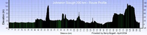
Route Profile
(Click image to enlarge)
|
Albion - Fort Langley 200 April 16, 7 a.m. Manfred Kuchenmuller @ the Albion Hall just north of the Lougheed Highway on 240th Street, Maple Ridge (Return to Albion Hall by catching the Ft. Langley ferry - Free) Route Profile (Click image to enlarge) |
Route Sheet:
|
(cum.) |
|
|
(int.) |
| 0 | R | South on 240th St. thru lites over RR tracks | 0.4 |
| 0.4 | R | West on River Rd. | 2.8 |
| 3.2 | R | #7 East to Juntion #7 & #9 at Agassiz | 71.9 |
| 75.1 | BL | Stay on # 7 East to Johnston Slough Rest area | 14.6 |
|
Johnston Slough Rest Area |
|||
| 89.7 | R | # 7 West | 5.5 |
| 95.2 | R | Wahleach Rd. becomes Seabird Island Rd. | 8.5 |
| 103.7 | R | # 7 West | 1 |
| 104.7 | BL | # 9 South. Caution - Agassiz-Rosedale bridge very narrow | 7.8 |
| 112.5 | R | Old Yale Rd. Food available on NW corner of # 9 and Old Yale | 5.4 |
| 117.9 | L | Annis Rd. | 2.6 |
| 120.5 | R | Prairie Central | 6.5 |
| 127 | L | Prest Rd. | 1.6 |
| 128.6 | R | McGuire | 1.3 |
| 129.9 | BL | Chilliwack River Rd. | 2.5 |
| 132.4 | R | Promontory Rd. (becomes Watson Rd. at Vedder Rd.) | 2.4 |
| 134.8 | L | Tyson Rd | 0.8 |
| 135.6 | R | Keith Wilson Rd. | 7.6 |
| 143.2 | R | Boundary Rd. / # 2 Rd. | 2.2 |
| 145.4 | L | Interprovincial Hiway | 1.5 |
| 146.9 | R | # 3 Rd. | 0.8 |
|
|
|||
| 147.7 | L | South Parallel Rd | 9.2 |
| 156.9 | L | Whatcom Rd. | 2.3 |
| 159.2 | R | Vye Rd X Sumas Way (# 11) becomes Huntingdon at McCallum | 10.2 |
| 169.4 | L | Townline Rd. / 0 Ave. | 10.6 |
|
264th St. & 0 Ave. |
|||
| 180 | R | 264th St. | 18 |
| 198 | L | 88th Ave. | 6.2 |
| 204.2 | BR | Mavis St. | 0.2 |
| 204.4 | R | Glover Rd. X RR tracks to... | 0.1 |
| 204.5 | ...the Fort Pub | ||
|
|
|||
| Note: This is not the official route sheet. Ride organizers may make last minute changes because of road closures or other problems. The route sheet you receive at the start of the ride is the official one. | |||