Fall Flatlander 200
September 12, 2004, 7 a.m.
Keith Fletcher
Finish: Fort Langley Pub (Glover Road)
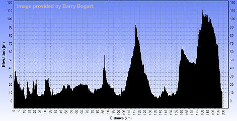
Route Profile
(Click to Enlarge)
|
Fall Flatlander 200 September 12, 2004, 7 a.m. Keith Fletcher Finish: Fort Langley Pub (Glover Road) Route Profile (Click to Enlarge) |
|
|
|
|
|
G0 kms |
|
240th St @ Route #7 Maple Ridge |
||||
| 0 | R | S | 240th St | 0.1 |
| 0.1 | L | E | Route #7 – Lougheed Hwy | 18.8 |
| 18.9 | R | SE | Route #11 – over Mission Bridge | 2.7 |
| 21.6 | BR | SE | Matsqui Exit off Bridge | 0.5 |
| 22.1 | R | S | Riverside Rd | 3 |
| 25.1 | L | E | Townshipline Rd | 0.4 |
| 25.5 | R | S | Riverside Rd | 0.8 |
| 26.3 | L | E | Clayburn Rd | 0.1 |
| 26.4 | R | S | Route #11 / Gladys Av., Abbotsford | 3.7 |
| 30.1 | SO | S | X Essendene Av onto Cyril St | 1.3 |
| 31.4 | BR | SW | Through Underpass | 0.2 |
| 31.6 | BR | SE | South Fraser Way | 0.1 |
| 31.7 | BR | S | Route #11 – Sumas Way | 0.5 |
| 32.2 | L | E | Delair Rd | 2.3 |
| 34.5 | R | SE | Lower Sumas Mountain Rd | 0.5 |
| 35 | R | S/E | North Parallel Rd | 1.3 |
| 36.3 | R | S | Whatcom Rd X Route #1 | 0.2 |
| 36.5 | L | NE | South Parallel Rd | 9.4 |
| 45.9 | BR | E | #3 Rd | 2.1 |
| 48 | L | N | Tolmie Rd | 1.5 |
| 49.5 | R | E/S | #2 Rd / Boundary Rd | 1.3 |
| 50.8 | L | E | X Vedder Canal onto Keith Wilson Rd | 2.6 |
| 53.4 | L | N | Sumas Prairie Rd | 3.2 |
| 56.6 | R | E | Yale Rd West | 3.3 |
| 59.9 | SO | E | X Lickman Rd onto Luckakuck Way | 5.2 |
| 65.1 | L | N | Chilliwack River Rd / Young Rd., Chilliwack | 1 |
| 66.1 | R | E | Airport Rd | 1.2 |
| 67.3 | L | N | Broadway | 2.3 |
| 69.6 | R | E | Yale Rd East | 0.2 |
| 69.8 | L | N | Menzies St | 0.8 |
| 70.6 | R | E | Hope River Rd | 3.1 |
| 73.7 | R | E | Camp River Rd | 8.2 |
| 81.9 | SO | E | Ferry Rd - pass under Rosedale Bridge | 2.7 |
| 84.6 | L | S | Route #9 – Rosedale-Agassiz Hwy | 1.9 |
| 86.5 | R | W | Yale Rd | 0.1 |
| 86.6 |
|
|||
| 86.6 | R | W | Yale Rd | 5.2 |
| 91.8 | L | S/W | Annis Rd (X Route #1) / Prairie Central Rd | 7.4 |
| 99.2 | L | S/W | Banford Rd (sign?) / Lindell Rd | 4 |
| 103.2 | SO | W | Bailey Rd | 2.3 |
| 105.5 | L | S | Chilliwack River Rd | 0.9 |
| 106.4 | R | W | Promontory Rd | 1.1 |
| 107.5 | L | S | Vedder Rd | 1.6 |
| 109.1 | L | E | Chilliwack Lake Rd | 7 |
| 116.1 |
|
|||
| 116.1 | L | W | Chilliwack Lake Rd | 7 |
| 123.1 | L | W | X Bridge to Vedder Mtn Rd / Yarrow Central Rd | 9.5 |
| 132.6 | L | S/W | Boundary Rd / Towne Rd / Campbell Rd | 5.5 |
| 138.1 | L | S/W | Interprovincial Hwy / Wellsline Rd | 2.8 |
| 140.9 | L | S/W | Powerhouse Rd / Vye Rd | 2.3 |
| 143.2 | L | S | Marion Rd | 1.1 |
| 144.3 | BR | S/W | Old Yale / Maher Rd | 4.5 |
| 148.8 | R | N | Lampson Rd | 0.8 |
| 149.6 | L | W | Vye Rd | 1.6 |
| 151.2 | L | S | Whatcom Rd / Boundary Rd / 2nd Av | 5 |
| 156.2 | R | N | Route #13 – Sumas Way, Huntingdon | 0.2 |
| 156.4 | L | W | 4th Av | 0.4 |
| 156.8 | R | N | Riverside Rd | 0.4 |
| 157.2 | L | W | Farmer Rd | 1.6 |
| 158.8 | R | N | McCallum Rd | 0.8 |
| 159.6 | L | W | Huntingdon Rd | 4.9 |
| 164.5 | L | S/W | Townline Rd / Zero Av | 10.9 |
| 175.4 | R | N | Route 13 / 264th St | 12.5 |
| 187.9 | L | W | 62nd Av | 1.7 |
| 189.6 | R | N/W | 256th St / 72nd Av | 4.7 |
| 194.3 | R | N | 240th St | 2.4 |
| 196.7 | R | E/N | Rawlinson Cres / 240th St / 88th Av / 240th St | 1.4 |
| 198.1 | L | W | River Rd | 1.6 |
| 199.7 | R | W | Mavis Av., Fort Langley | 0.2 |
| 199.9 | R | N | Glover Rd x RRX | 0.1 |
| 200 |
Fort Langley Pub |
|||
| Note: This is not the official route sheet. Ride organizers may make last minute changes because of road closures or other problems. The route sheet you receive at the start of the ride is the official one. | ||||
_