|
|
|
'Halfmoan' Populaire
Imperial Century - 160 km
May 29, 2004, 9 a.m.
Robert Irvine, Brad Proctor & Loraine Kless Proctor
(268 Gower Point Road)
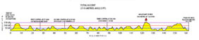
Profile - click to enlarge
'Halfmoan' Populaire Imperial Century - 160 km May 29, 2004, 9 a.m. Robert Irvine, Brad Proctor & Loraine Kless Proctor (268 Gower Point Road) Profile - click to enlarge |
|
|
|
|
|
G0 kms |
| 0.0 | Start | N |
268 Gower Point Road |
0.05 |
| 0.05 | L | SW | Southwest on Gower Point Road | 0.30 |
| 0.35 | SO | SE | Though 3-way and continue on Dougal Rd | 0.60 |
| 0.95 | R | SW | Headland Dr. | 0.30 |
| 1.25 | R | SW | Burns Road | 0.50 |
| 1.75 | L | W | Gower Point Road | 1.70 |
| 3.45 | R | N | Pratt Road | 2.20 |
| 5.65 | L | W | Sunshine Coast Highway | 2.40 |
| 8.05 | BL | NW | Lower Road (Cemetary on Right) | 6.30 |
| 14.35 | L | SW | Roberts Creek Road | 0.05 |
| (Store on left) | ||||
| 14.40 | VR | NW | Beach Ave | 2.20 |
| 16.60 | R | N | Flume Road | 0.60 |
| 17.20 | L | W | Sunshine Coast Highway | 5.70 |
| 22.90 | SO | NW | Pier 17 | 4.20 |
| 27.10 | L | W | Wharf Street at lights | 0.30 |
| 27.40 | BR | W |
- On the Edge Bike Shop - |
|
| 27.40 | R | W | Cowrie St. | 0.05 |
| 27.45 | L | S | Inlet Ave | 0.10 |
| 27.55 | SO | W | Teredo into Sunshine Coast Highway | 7.00 |
| 34.55 | L | W | Redrooffs Road (southend) | 10.50 |
| 45.05 | L | N/W | Sunshine Coast Highway | 0.90 |
| 45.95 | L | W | Brooks Road | 3.40 |
| 49.35 | T |
- Smugglers Cove Parking Lot - (Turn Around) |
||
| 49.35 | L | E | Brooks Road | 3.40 |
| 52.75 | L | N/W | Sunshine Coast Highway | 3.70 |
| 56.45 | L | N/W | Mercer Road | 2.70 |
| 59.15 | L | N/W | Sunshine Coast Highway | 9.40 |
| 68.55 | L | NW | Frances Peninsula Road | 0.80 |
| 69.35 | R | N | Lagoon Road | 1.20 |
| 70.55 | R | E | Gonzales Road | 0.10 |
| 70.65 | L | S | Madiera Park Road | 0.60 |
| 71.25 | L | N | Sunshine Coast Highway | 5.70 |
| 76.95 | L | NW | Garden Bay Rd (Petrocan Station on corner) | 5.30 |
| 82.25 | SO | S/W | Irvines Landing Road | 2.60 |
| 84.85 | L | E | Hotel Lake Road | 0.70 |
| 85.55 | R | S | Sinclair Bay Road | 1.90 |
| 87.45 | R | S | Garden Bay Rd | 0.60 |
| 88.05 | BR | NW | Poole Road | 0.10 |
| 88.15 |
- John Henry's Store - |
|||
| 88.15 | BL | N | Poole Road | 0.10 |
| 88.25 | BR | N | Garden Bay Rd | 7.80 |
| 96.05 | R | SW | Sunshine Coast Highway (Petro Can) | 16.20 |
| 112.25 | R | S | Mercer Road | 2.70 |
| 114.95 | R | SE | Sunshine Coast Highway | 19.10 |
| 134.05 | L | N | Inlet Ave | 0.10 |
| 134.15 | R | E | Cowrie St. | 0.10 |
| 134.25 | L | N | Wharf St. | 0.30 |
| 134.55 | BR | E | Sunshine Coast Highway | 20.20 |
| 154.75 | R | S | Veterans Road | 0.60 |
| 155.35 | R | W | Fitchett Road | 0.20 |
| 155.55 | L | S | King | 1.00 |
| 156.55 | R | W | Chaster Road (Seventh Road) | 0.90 |
| 157.45 | L | SE | Gower Point Road | 3.40 |
| 160.85 | R | E | Franklin Road | 0.50 |
| 161.35 | L | NW | Burns Road | 0.00 |
| 161.35 | SO | NE | Headland Dr. | 0.30 |
| 161.65 | L | NW | Dougall | 0.60 |
| 162.25 | R | NW | Gower Point Road | 0.30 |
| 162.55 |
|
|||
| Note: This is not the official route sheet. Ride organizers may make last minute changes because of road closures or other problems. The route sheet you receive at the start of the ride is the official one. | ||||
_