 |
|
|
|
|
|
|
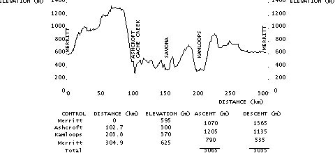
(cum.) |
|
|
|
(int.) |
|
7-11 Convenience Store SE corner Voght St. & Nicola Ave |
||||
| 0.0 | L | W | NICOLA AVENUE (HWY. #8/97C) | 4.8 |
| 4.8 | R | N | HIGHWAY #97C (MAMIT LAKE ROAD) | 42.0 |
| 46.8 | L | W | HIGHWAY #97C (HIGHLAND VALLEY RD.) | 55.5 |
| 102.3 | BL | W | 1st STREET | 0.2 |
| 102.5 | L | S | RAILWAY AVENUE | 0.2 |
| 102.7 |
Secret Garden Restaurant |
|||
| 102.7 | T | N | RAILWAY AVENUE | 0.2 |
| 102.9 | L | W |
1st STREET (Ashcroft Bridge over Thompson River) |
0.4 |
| 103.3 | R | N | HIGHWAY #97C | 5.9 |
| 109.2 | R | N | HIGHWAY #1 | 4.2 |
| 113.4 | BR | E | HIGHWAY #1/97 | 75.6 |
| 189.0 | BR | E | EXIT 366 (COPPERHEAD DRIVE) | 0.1 |
| 189.1 | L | N | COPPERHEAD DRIVE (over HWY.#1) | 0.2 |
| 189.3 | R | E | HILLSIDE DR. (becomes NOTRE DAME DR.) | 3.5 |
| 192.8 | L | N | DALHOUSIE DRIVE | 0.4 |
| 193.2 | R | E | MCGILL ROAD | 0.5 |
| 193.7 | L | N | SUMMIT DRIVE | 3.0 |
| 196.7 | R | S | OVERLANDER BRIDGE (follow BIKE RTE.) | 1.0 |
| 197.7 | L | N | KITCHENER CRESCENT | 0.3 |
| 198.0 | R | E | BEACH AVENUE | 0.3 |
| 198.3 | L | N |
SCHUBERT DRIVE (follow ramp to access HALSTON BRIDGE) |
3.3 |
| 201.6 | R | E | HALSTON BRIDGE (HALSTON AVENUE) | 2.2 |
| 203.8 |
Husky Service Station (@ junction with HIGHWAY #5) |
|||
| 203.8 | L | S | HIGHWAY #5 (YELLOWHEAD HWY.) | 1.7 |
| 205.5 | BR | S | MT. PAUL WAY (over RED BRIDGE) | 1.8 |
| 207.3 | R | W | LORNE STREET | 1.1 |
| 208.4 | BR | W | LANSDOWNE ST. (becomes VICTORIA ST.) | 0.7 |
| 209.1 | CO | W |
VICTORIA STREET (under bridge-becomes SUMMIT DRIVE) |
7.8 |
| 216.9 | L | S | HIGHWAY #5A (to Merritt) | 88.0 |
| 304.9 |
Robin's Donuts (3643 Voght Street, beside_Turbo_Service_Station) |
|||
| Note: This is not the official route sheet. Ride organizers may make last minute changes because of road closures or other problems. The route sheet you receive at the start of the ride is the official one. | ||||