| Newsletter - 2015 Archive |
|
Cycling Club |
 |
| Newsletter - 2015 Archive |
|
Cycling Club |
|
Next--->
|
Heart of the Kootenay SR600 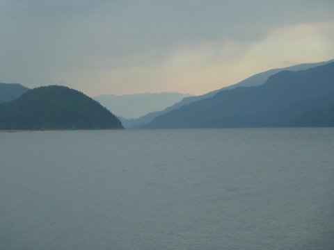
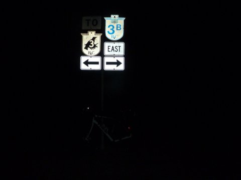
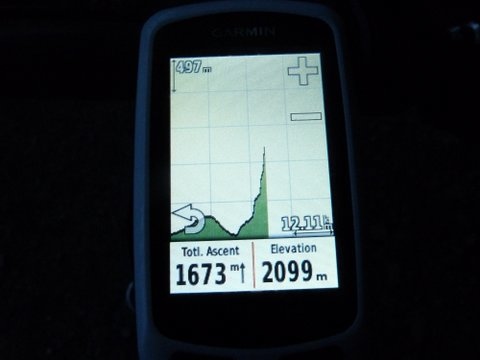
I have been thinking about creating this ride for a couple of years. Ever since hearing about the Super Randonnee 600 and Randonneur 10,000 concept I have thought that we should have such a ride in Canada. Now we do. The concept is simple. Ride 600 km as a permanent in 50 hours. The kicker is that there needs to be at least 10,000 meters of climbing in those 600 km. That means the ride has to be in the mountains. BC has mountains. I thought that it should not be a problem. It turned out to be a big problem. While BC has lots of big mountains it also has lots of valleys and very few roads that climb over those mountains. The roads tend to travel for long distances through the valleys and then pop over the mountains (albeit on some very long climbs) to reach the next valley. After much playing around with Google Maps and RideWithGPS I finally found a route that would work. It took a lot of planning and back and forth negotiating with Sophie Matter, the head honcho in France in charge of all things extreme, to get preliminary approval for the route. Sophie being Sophie there was an unwritten rule that I needed to satisfy. Not only did the route need to be extremely difficult but it also needed to be worthwhile. Truth be told though I had absolutely no problem with that rule. If Sophie hadn't enforced it I would have. I think that rides should be aesthetic, that they should go to interesting places and should challenge and enrich both the body and the soul. This ride certainly met those criteria. The only place that I could find that had enough climbing was the West Kootenay region of the southern interior of BC. I used to live in the area in Rossland and that's where I started going for long rides on my bike. So I knew the roads and I knew how incredibly beautiful the landscape is. There was still a problem though. Even with a route that climbed every major paved pass in the West Kootenay, some on them in both directions, I still didn't have the required 10,000 meters of climbing. The only way to get the requisite uphill was to add in the Idaho Peak road. This monster climbs 1300 meters in only 18 km but it does it on gravel. I had only ever been there once, many years ago in a car. I checked with Sophie to see if it would be possible to switch bikes for this climb and do it on a mountain bike. After some thought she agreed that it would be OK and within the rules to do that, but in order to meet the criteria of self sufficiency I would have to stash the mountain bike at the base of the climb myself. It wouldn't be allowed to have someone else do the job or meet me there with the bike when I arrived. And so with the rules established and the time allocated to do the ride I headed out to the Kootenays. The game was afoot. I drove to Kaslo to the home of my good friends Paul and Osa. I spent a few days hiking and generally enjoying life while waiting for suitable weather. I didn't want to ride in the extreme heat and forest fire smoke that had been plaguing BC for much of the summer. Nor did I want heavy rain. In the end I got very lucky and got cool and showery weather. I only ever put my raincoat on once although I rode through and around showers several times. I left Kaslo early on Tuesday morning and went to the base of Idaho Peak to stash my mountain bike. After locking it to a post at the start of the gravel I carried on up the road to see what I was getting into. This climb was after all the big unknown of the entire ride. I drove all the way up and then hiked the trail from the parking lot to the fire lookout. This is a highly recommended side trip for anyone who does this ride. It takes a little over an hour out and back if you are in a hurry. The 360 degree views from the lookout are outstanding. And the wildflowers up there cannot be believed. 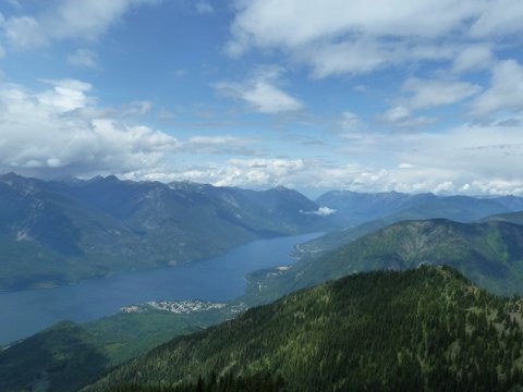
I then drove back down the mountain, through the Slocan Valley, and on to Christina Lake and the start of the ride. The start was to be at the Wild Ways Adventure Sports store. The people there were very nice and were happy to let me leave my car in the corner of their parking lot. I quickly suited up and was ready to start the epic adventure. Day 1 Then I headed out and started back up the glorious descent that I had just enjoyed. In all the years I lived in Rossland I had ridden down to Trail many times, and I had ridden up to Nancy Greene summit many times. But I had never ridden from Trail to Nancy Greene. There was just never any reason to ride past my house and keep climbing. Now there was a reason. I got back up to Rossland well enough although I walked many stretches of this steep climb because I could feel my legs cramping up. In Rossland I hoped to get water but it was now after 11 pm and even the pub was closed. I managed to find an outside garden hose at an apartment building to fill my bottles and then carried on with the climb up past Red Mountain and on to Nancy Greene. By Day 2 After Salmo the route goes over Kootenay Pass. This is the highest paved road in BC (but not the high point of the route). It's also 90 km from Salmo to Creston and there are no services in that distance. I knew that I needed fuel in Salmo. I got there at about 5:40 am and of course nothing was open. There is a highly recommended restaurant (the Dragonfly) but it had no posted hours. There is a gas station and a Subway that both opened at 6 am. I opted for the Subway. Bad choice. The place opened on time and the attendant had coffee going. But she needed to warm up the oven in order to make me the egg sandwich that I wanted. She promised 10 minutes. It took 20 and the oven still wasn't up to temperature when I insisted that she make the sandwich anyway. In the meantime I whiled away the time listening to the village nut case fill me in on how he was going to save the world. Or maybe he was only going to save Canada. I wasn't totally clear on that point. His plan was to sue the RCMP for $100 million because someone had broken into his house and they had failed to apprehend the nefarious criminal responsible. With the money he was sure that he would win he was then going to start his own political party which he would call the Commonsense of the People Party (COPP, get it?). Of course, since common sense is not at all common (I totally agreed with him on that point) he was sure that he would never find any candidates other than himself to run for office. So he was going to have to save Canada (or was it the world?) all by himself. By the time he got done explaining all this to me my sandwich was finally ready. I wolfed the sandwich, gulped the coffee, wished him well and promised to vote for him, and headed for the high country for climb number 4. I was still chuckling by the time I got to Kootenay Pass. Now I was 2.5 hours behind my planned pace. But I had 4 of the six major climbs done and was facing a 45 km downhill and then 80 km of rolling terrain along the east shore of Kootenay Lake. I knew that I could make up some time. The downhill was quick. I found the third and last 24 hour Tim Hortons in the Kootenays at the junction of Hwy 3 and 3A. I stopped for some calorie replenishment but found to my amazement that I couldn't eat all of an egg biscuit sandwich. My appetite was deserting me. Usually I find that my appetite increases during the second day of a ride and then decreases after that as my body gets used to the exertion and enters a kind of steady state where calories out equals calories in. This time I just didn't seem to want calories in at all. I never really bonked though. The road along the east shore of Kootenay Lake is incredibly beautiful and has low traffic. It may be one of the nicest stretches of road in BC. I enjoyed every minute of it. I also made very good time. I had the ferry schedule in my head and decided that I could make the 2:50 pm ferry if I pushed hard and stayed on the bike continuously for the next 78 km. I did exactly that and got to the ferry at 2:40 pm. I was now back to the schedule that I had originally planned, having made up 2.5 hours on the clock in the last 5 .75 hours of riding. The ferry took 35 minutes to cross the lake. The next section to Kaslo was only 35 km but featured much rolling terrain and a couple of very steep hills. I finally got to Kaslo at 5:30 pm. Paul and Osa were having dinner and of course offered me some but I didn't want any. The weird appetite thing again. I did manage to get 3 hours of glorious sleep and when I woke up I had a bowl of cereal and a cup of coffee. Day 3 I rode back down to my stashed bike in good time and switched back to road mode. Then it was down to New Denver for a breakfast that I thought I actually wanted. It wasn't to be though. I got there at about 6:45 am and nothing was open. On to Silverton. Again, nothing open. So I went on to Slocan City after slogging up an incredibly rude 300 meter climb that caught me by surprise. In Slocan City I found the Harold Street Café just opening up at 9 am. I ordered a substantial breakfast and then ate only part of it. I still had no real appetite but knew that I needed calories. Then I carried on down the Slocan Valley for a couple of hours. At this point I was getting very tired and needed a nap. This area is pretty dry and the grass at the side of the road is of poor quality from a nap perspective. Finally I was able to sleep like a dead person in a cemetery. The nice thing about cemeteries is that the grass is usually well taken care of. And the residents don't mind you sleeping on their lawn. After 10 minutes on the ground I was refreshed enough to carry on. The day was now getting quite warm and the wind was starting to blow. Of course it was blowing toward me. And it was steadily increasing in strength. I stopped for some chocolate milk and then went on to Castlegar. My pre-planned schedule had me leaving Castlegar for the last climb of the ride at 1:30 pm and I actually got started on it at 1:15 pm. It was starting to look like I was going to get this thing done. I knew that there was a gas station / C-store at the top of the initial steep section of the climb. I decided to use that as my final fuel up station before the 50 km of climbing to the end of the ride. But when I got there I found that the gas station was gone. No food available. I was able to fill my bottles at a campground but was now facing the last climb into a stiff headwind with no food left on my bike but a cliff bar and a chocolate bar. I choked down the cliff bar with substantial difficulty and ate half the chocolate bar with less difficulty. Then I slogged uphill into the wind. I drained my bottles as I rode but was able to find water from a pump at the provincial park campground at Nancy Greene Lake. There was a boil water advisory sign on the pump so I sterilized the water with my Steri Pen. Then I rode the final stretch to Bonanza Pass and rolled down to the finish at the Paulson Bridge and finished the ride in 48:49. From there I still had 25 km to go to get back to my car. Almost all if that was downhill so it wasn't much of a hardship. I got to Christina Lake in good time and knew that trying to drive back to Kaslo that night would be a very bad idea so I got a motel room. I had a shower and wanted to go out for a good dinner and maybe a beer or two to celebrate. First thing though was to have a short nap. I woke up from my short nap 11 hours later and went looking for a coffee instead. I still wasn't hungry even though I was now 24 hours from my previous breakfast in Slocan City with just some chocolate milk, a Cliff Bar and half a chocolate bar for calories since then. 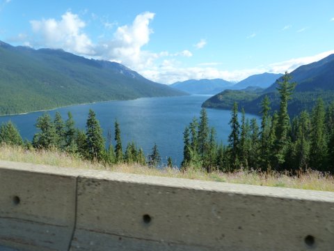
It was several days before my appetite returned. Conclusion
• Don't count on finding services between 9 pm and 6-9 am depending on where you are. Carry enough food on the bike to get you through the night. The rules for Super Randonnees can be found here... http://www.audax-club-parisien.com/EN/421.html If you want to do this ride contact me at: Bob at koen dot ca Strategy The other strategy would be to leave Christina Lake much later than I did and plan to rest in Crawford Bay and then take the 7 am ferry. This strategy gets you up Idaho Peak in the daylight but you ride more passes during the heat of the day.
Additional from Ron S: And anybody with 650b wheels who just wants to borrow the tires is welcome. Fee: One beer. ronald at moonset dot ca
August 6, 2015 |