| Newsletter - 2004 Archive |
|
|

|
Cycling Club |
|

|
| Newsletter - 2004 Archive |
|
|
|
Cycling Club |
|
|
Next--->
|
Barry Bogart has been generating elevation profiles. He isolated the Woodside hill near Agassiz from his LM spring 200 km route, and this was posted on the web site a couple of weeks ago. This profile is what Wim is referring to. Here is the image in question - click to enlarge: 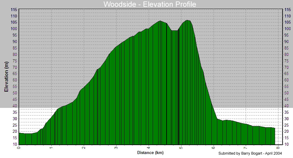 Making a Mountain out of a Molehill?
by E.W. (Wim) Kok, Brevet Organizer, Peace Region When the profile of the Woodside road first appeared on my computer screen, I held on to my chair, cold sweat broke out, and I froze. Flashbacks from Mount Trevezel! What a mountain to climb. Who was so cruel as to place this monstrous challenge in a randonneur's quest to finish? Imagine arriving at Km 0 of this Woodside road section, the BLACK mountain looms. (Cruelty seems to know no bounds if one had to start on the other side at Km 7). So imagine approaching this mountain: the pace slows, the crawl begins, gears shifting down, resolve shifts up and into overdrive. Arrgh, one revolution; arrgh, another revolution, and so it continues, pushing forward, inching upward. Panting near exhaustion, profusely sweating, muscles cramping. The rando's tongue hangs over the handlebars, dragging over the front tire. No mercy. Vivid images of mountain scenes in "Triplettes de Belleville." So steep! Would the cyclist fall over backward during the ascent? Would this Woodside hill become a nemesis? Finally, the first summit, then a small cleavage in the profile, followed by a small lump at Km 5.2. What are we looking at then? The abyss, a descent into a gaping hole. Wondering "should the bike have been equipped with an ejection seat?" Then with a 1-2-3 "hat er sich nach Unten gestuerzt" (dropped like a bomb) over a distance of less than a kilometer to coast down a more reasonable grade in the final stretch. Victory. Ah, the beauty and power of a profile. It can instill fear! It may make even the mighty tremble (and humble). Then a sober second look, the fine print. I relax. It is only a profile, which made a mountain out of a molehill. So let's rent a few proverbial picks, shovels and buckets and deconstruct the mountain, and turn it back into what it really is: a molehill. Check the scale. The vertical scale 1:900 (minus the change), the horizontal scale 1:107,142 (plus the change) for a vertical exaggeration of almost 119 X. Phew, no wonder! Further calculations show that one side of Woodside has a 2 % grade; the abyss 7.5%. So relax, the ride might be a picnic after all. PS: Vertical exaggeration is a cartographic tool used to accentuate the terrain lumps. With a 1:1 scale even Mt Everest would disappear from a profile of the surface of the earth, so we know the rationale. Also, colour - in this case 'black' - is used as a 'propaganda' tool in representation. As long as we are aware of this, life on the bike will be a lot easier (or not). _ |