|
Southern Coast 400 km July 14, 5 a.m. Ride Organizer: Start/Finish: Victoria, 2860 Colquitz Ave Route Sheet Map Notes from Steve at bottom of page |
| Note: This is not the official route sheet. Ride organizers may make last minute changes because of road closures or other problems. The route sheet you receive at the start of the ride is the official one. |
Caveat - This is a new route. We have driven the first 310 km, and
cycled the last 95 km. A word to the wise - trust the 'go to' distance
more than the overall distance.
The overall route is a figure 8. The start, Control #4 (310 km), and
finish our at our home. You are welcome to leave a drop bag with us,
take a shower and/or nap while at Control #4 while it is open between
2:20 PM Saturday and 1:42 AM Sunday. For that matter only one of our
two spare beds have been spoken for on the Friday & Saturday night (more
room if you bring a tent/Van/camper).
That said, this will be a grand ride, stretching out the downhills and
abbreviating the uphills. You will see plenty of pastoral farmland,
vast forests and plenty of coastline. Should the weather co-operate you
may even get a strong tailwind from Port Renfrew to Sidney. While it
has 4947 m of climbing, we have tried to spread the hilly bits over the
first 300+ km leaving the last 60 km reasonably flat.
>From our house, you have a wee climb up the Malahat to start your day.
Hazards include rumble strips, debris, construction and the crossing to
South Shawnigan Lake road. Your reward is a prolonged downhill to
Cowichan Bay for your morning coffee. From Cow bay following the
'Rotary Route', keep an eye out for these signs particularly while you
are looking for Herd Rd.
You will end your Northbound journey in Chemainus (for breakfast?) at
Utopia Bakery & Cafe. With luck the forecast will hold and your
Westbound ride will be basking in a comfortable amount of sunshine. The
route from Chemainus to Lake Cowichan, then beyond to Sooke is not
'remote', however services are only available in the towns. There are
numerous single lane bridges as well as at least two areas of
construction to be wary of. Take the time to check out the wharf in PR,
on the drive we were entertained by eagles within 30 m, the scenery is
gorgeous.
The road from PR to Sooke is good with the exception of a severe
downhill switchback (not to be taken lightly!) and construction around
it to replace that section. There is road edge slippage to be wary of
as well.
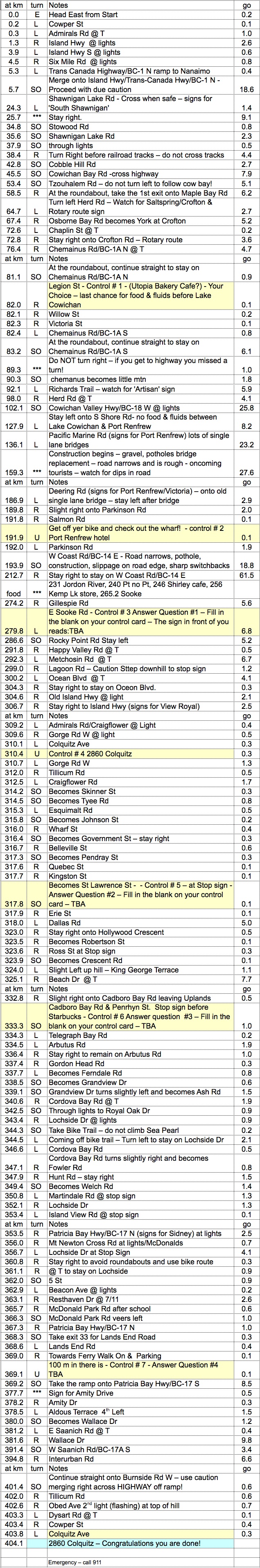
Coming off Gillespie Road you will encounter the first control with a
'fill in the blank' question. A sign will be referred to and you will
be asked to complete (on your control card). For example:
Your route sheet will read "Control #00 - Answer question #000 Fill in
the blank on your control card. The sign at the corner of Maple Bay road
& Herd road reads: Crofton, _________ Spring Ferry"
Fill out your Control Card under the 'Establishment' as follows:
Crofton
Salt____ Spring
Ferry
Sign and time of passage your card.
Potential questions may be derived from (in no particular order):
Navigation is fairly simple from Duncan back to Victoria. However the
trip out to Lands End and back will throw at least four curves in your
direction.
On Lochside Drive you will need to take a bike trail:
The turn at Hunt road has a hidden 'off ramp':
Avoiding the airport nightmare roundabouts will call for a slight
diversion:
And the sign for Amity Drive is 1/2 a km ahead of the actual off ramp:
I would recommend you review the route in 'satellite view' at;
http://ridewithgps.com/routes/1334873
For our techno-randos, the GPS file appears to be correct.
There have been changes to the route sheet as posted on the Randonneur
website - remember the route sheet you receive the day of the event is
the correct one (and supersedes the GPS file!).
_