Tour des Lacs 400
May 23, 6 a.m.
Susan Allen & Doug Latornell
Finish: Vancouver - Knight & Day restaurant (Boundary & Broadway)
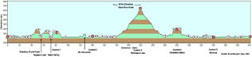
Click to Enlarge
(Profile from 2005 version of the route, by Brad Mcguire)
(Thanks to Ryan Golbeck)
|
Tour des Lacs 400 May 23, 6 a.m. Susan Allen & Doug Latornell Finish: Vancouver - Knight & Day restaurant (Boundary & Broadway) Click to Enlarge (Profile from 2005 version of the route, by Brad Mcguire) (Thanks to Ryan Golbeck) |
|
(cum.) |
|
|
|
G0 kms |
|
E 4th Ave just west of Boundary Rd |
||||
| 0.0 | R | S | Boundary Rd (no sign) | 0.1 |
| 0.1 | L | E | Lougheed Hwy [Hwy 7] | 4.2 |
| 4.3 | BR | SE | Winston Slip/Winston St/ Government | 6.3 |
| 10.6 | R | SE | Lougheed Hwy [Hwy 7] | 3.0 |
| 13.6 | R | S | King Edward Ave | 0.4 |
| 14.0 | L | E | United Blvd | 3.3 |
| 17.3 | BR | E | HWY-7B [Mary Hill Byp] | 7.2 |
| 24.5 | BR | E | HWY-7 [Lougheed Hwy] (no sign) | 1.4 |
| 25.9 | L | N | Dewdney Trunk Rd (first left) | 2.3 |
| 28.2 | R | S | Harris Rd (at T) | 0.2 |
| 28.4 | L | E | Old Dewdney Trunk Rd (first left)/ 210 St | 4.5 |
| 32.9 | L | E | 128 Ave/127 Ave | 2.8 |
| 35.7 | R | S | 224 St (at T) | 0.2 |
| 35.9 | L | E | Abernethy Way (first left) | 1.6 |
| 37.5 | R | S | 232 St (at TL) | 0.8 |
| 38.3 | L | E | Dewdney Trunk Rd | 3.2 |
| 41.5 |
volunteers will be there (leg length 41.5 km) |
|||
| 41.5 | CO | E | Dewdney Trunk Rd | 9.4 |
| 50.9 | R | S | Wilson St | 2.8 |
| 53.7 | L | S | Hayward St (first left, no sign,across the dam) | 1.5 |
| 55.2 | L | E | Keystone Ave | 6.5 |
| 61.7 | CO | E | Dewdney Trunk Rd (not left yet) | 1.3 |
| 63.0 | ST | E | Dewdney Trunk Rd/Ferndale (MUS Dewdney Trunk & Cedar, go E not N up the hill) | 2.4 |
| 65.4 | L | N | Stave Lake St | 0.8 |
| 66.2 | R | NE | Stave Lake St | 0.1 |
| 66.3 | CO | NE | Stave Lake St (MUS Stave Lake & Kirkpatrick, keep L on main road) | 3.4 |
| 69.7 | L | N | Stave Lake Rd | 2.7 |
| 72.4 | L | N | Stave Lake Rd | 0.5 |
| 72.9 | L | N | Stave Lake Rd | 2.9 |
| 75.8 | R | E | Hartley Rd | 1.9 |
| 77.7 | L | N | Spratt Rd/Kontney Rd | 2.3 |
| 80.0 | L | N | Sylvester Rd (no sign, at T, cross concrete bridge) | 1.1 |
| 81.1 |
Info control (leg length 39.6 km) |
|||
| 81.1 | UT | S | Sylvester Rd (Allan Lake on Right) | 14.5 |
| 95.6 | L | E | Hwy-7 [Lougheed Hwy] (at T) (JR Food and Gas) | 39.6 |
| 135.2 | ST | N | Hot Springs Rd | 6.3 |
| 141.5 |
On your own (leg length 60.4 km) |
|||
| 141.5 | UT | S | Hot Springs Rd | 6.3 |
| 147.8 | L | E | HWY-7 [Lougheed Hwy] | 1.6 |
| 149.4 | BR | S | HWY-9 [Agassiz-Rosedale Hwy] | 0.3 |
| 149.7 | L | E | HWY-9 [Cheam Ave] | 0.3 |
| 150.0 | R | S | HWY-9 [Agassiz-Rosedale Hwy] | 1.7 |
| 151.7 | R | S | HWY-9 [Agassiz-Rosedale Hwy] | 4.9 |
| 156.6 | R | SW | Yale Rd E | 5.4 |
| 162.0 | L | S | Annis Rd/Prairie Central | 7.4 |
| 169.4 | L | S | Banford Rd/Lindell Rd/Bailey Rd | 6.2 |
| 175.6 | L | S | Chilliwack River Rd | 0.9 |
| 176.5 | R | W | Promontory Rd | 0.5 |
| 177.0 | L | S | Thomas Rd | 1.1 |
| 178.1 | L | S | Vedder Rd | 1.1 |
| 179.2 | L | SE | Chilliwack Lake Rd (before bridge) | 7.0 |
| 186.2 |
Restaurant closes 8 pm, store at 6 Volunteers will be there (leg length 44.6 km) |
|||
| 186.2 | CO | SE | Chilliwack Lake Rd | 33.2 |
| 219.4 |
Info control (leg length 33.2km) |
|||
| 219.4 | UT | W | Chilliwack Lake Rd | 33.2 |
| 252.6 |
Restaurant closes 8 pm, store at 6 Volunteers will be there (leg length 33.2 km) |
|||
| 252.6 | CO | W | Chilliwack Lake Rd | 7.0 |
| 259.6 | L | SW | Vedder Mtn Rd (no sign, at T, cross bridge) | 0.7 |
| 260.3 | L | S | Cultus Lake Rd/Columbia Valley Hwy | 14.4 |
| 274.7 | R | W | Iverson Rd | 4.7 |
| 279.4 |
Info control (leg length 26.8 km) |
|||
| 279.4 | CO | S | Iverson Rd | 0.2 |
| 279.6 | L | E | Henderson Rd (no choice) | 2.7 |
| 282.3 | L | N | Maple Falls Rd (no choice)/ Kossikar Rd | 2.9 |
| 285.2 | R | SE |
Columbia Valley Hwy (no sign, at T)/ Cultus Lake Rd (296.9 km pub/store/gas) Restaurant (in Plaza) closes 11 pm, Pub closes 1 am. |
14.2 |
| 299.4 | L | NW | Vedder Mountain (no sign, at T)/ Yarrow Central Rd | 8.5 |
| 307.9 | L | S | Boundary Rd (at T) | 0.8 |
| 308.7 | R | W | No 4 Rd | 4.9 |
| 313.6 | L | SW | S Parallel Rd | 10.4 |
| 324.0 | R | N | Sumas Way [HWY-11] | 0.9 |
| 324.9 | L | W | Marshall Rd | 0.4 |
| 325.3 | R | N | Riverside Rd | 0.8 |
| 326.1 | BR | NW | West Railway St | 0.9 |
| 327.0 | L | W | Essendene Ave | 0.1 |
| 327.1 | R | N | Montrose Ave | 0.1 |
| 327.2 | L | W | George Ferguson Way | 2.0 |
| 329.2 | R | N | Gladwin Rd | 5.4 |
| 334.6 | R | E | Harris Rd | 1.6 |
| 336.2 | L | N | Riverside St (watch traffic calming medians) | 2.0 |
| 338.2 | L | NW | Ramp onto Mission Bridge | 1.1 |
| 339.3 | BR | NE | First exit Ramp (watch storm drains) | 1.2 |
| 340.5 | L | NW | Horne St (no sign, at T) | 0.2 |
| 340.7 | R | NE | Murray | 0.3 |
| 341.0 | L | W | HWY-7 [1st Ave] | 0.1 |
| 341.1 |
Tim Hortons (trailer only) on right, Petrocan on left (leg length 61.7 km) |
|||
| 341.1 | CO | W | HWY-7 [1st Ave] | 23.5 |
| 364.6 | L | W | Haney Byp | 2.6 |
| 367.2 | L | W | HWY-7 [Lougheed Hwy] | 10.3 |
| 377.5 | L | W | HWY-7B [Mary Hill Byp] | 7.4 |
| 384.9 | L | W | United Blvd | 3.3 |
| 388.2 | R | N | King Edward ave | 0.4 |
| 388.6 | L | W | HWY-7 [Lougheed Hwy] | 12.7 |
| 401.3 |
Knight and Day Restaurant (leg length 60.2 km) |
stop | ||
| Note: This is not the official route sheet. Ride organizers may make last minute changes because of road closures or other problems. The route sheet you receive at the start of the ride is the official one. | ||||
Some comments from the pre-ride:
1. MUS: messed up signs, someone
out in Mission has been turning
signs 90 degrees. Noted on route sheet.
2. Detour through Harrison Hot Springs is no longer necessary
3. Weather was glorious. 7 Volunteers finished... but did you
know:
Knight and Day is not open on Sunday nights!
Helpful info
can be found in Susan detailed route description
put together after the first pre-ride of this route back in 2005:
The
Road Ahead: Lower Mainland 400
_