|
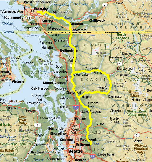
Lower Mainland Summer 600 Saturday/Sunday, August 24/25, 6:00 a.m. Start: Lougheed Mall, Burnaby, corner of North Road & Austin Ave. Finish: Across the road at Denny's, Coquitlam. |
|
KM |
|
|
|
KMS |
| 0 | L | E | Austin Av | 0.1 |
| 0.1 | R | S | North Rd | 0.3 |
| 0.4 | L | E | Hwy #7 - Lougheed | 5.5 |
| 5.9 | BR | S | Off ramp for Hwy #7B-United Blvd | 1.1 |
| 7 | L | E | Hwy #7B – Mary Hill By Pass | 7.2 |
| 14.2 | R | E | Hwy #7 - Lougheed | 10.5 |
| 24.7 | BR | SE | Haney By Pass | 2.6 |
| 27.3 | Br | E | Hwy #7 - Lougheed | 20.7 |
| 48 |
Convenience Store, Wren Street |
|||
| 48 | L | E | Hwy #7 - Lougheed | 0.9 |
| 48.9 | R | SE | Hwy 11, Mission | 2.7 |
| 51.6 | BR | SE | Matsqui Exit off bridge | 0.5 |
| 52.1 | R | S | Riverside Rd | 3.1 |
| 55.2 | L | E | Townshipline Rd | 0.4 |
| 55.6 | R | S | Riverside Rd | 0.8 |
| 56.4 | L | E | Clayburn Rd | 0.1 |
| 56.5 | R | S | Hwy #11 / Gladys Av., Abbotsford | 3.7 |
| 60.2 | R | W | Essendene Av | 0.1 |
| 60.3 | L | S | West Railway St | 1 |
| 61.3 | L | SE | Riverside Rd | 4.5 |
| 65.8 | L | E | 4th Av., Huntingdon | 0.4 |
| 66.2 | R | S | Hwy # 11 to US Customs | 0.5 |
| 66.7 | SO | S | Cherry St., Sumas | 1 |
| 67.7 | L | E | Front St | 0.5 |
| 68.2 | R | S/W | Hovel Rd / Nth Telegraph Rd / Sorenson Rd | 7.4 |
| 75.6 | L | S/W | Goodwin Rd / Hopewell Rd | 6 |
| 81.6 | L | S | Siper Rd | 2.9 |
| 84.5 | L | SE | Hwy #9 | 1.7 |
| 86.2 | L | SE | Hwy #9 joins State Route #542 | 7.4 |
| 93.6 | R | S | Hwy #9 leaves SR #542 | 35.7 |
| 129.3 |
|
|||
| 129.3 | L | E | Hwy # 20 – North Cascades | 50.6 |
| 179.9 | R | S | SR # 530 @ Rockport | 30 |
| 209.9 |
|
|||
| 209.9 | R | W | SR # 530 to Division St, Arlington | 44.9 |
| 254.8 | L | S | North French St / South French St | 1.2 |
| 256 | L | E | Highland Dr | 0.4 |
| 256.4 | R | S | Burn Rd / 83rd Av. NE | 3.1 |
| 259.5 | BL | SE | Burn Rd | 10 |
| 269.5 | R | S | Burn Rd / 159th Av NE / 100th St NE | 4.5 |
| 274 | R | S | Jordan Rd | 0.5 |
| 274.5 | L | E | Hwy # 92 / Stanley Rd., Granite Falls | 0.6 |
| 275.1 |
Tom Thumb Grocery |
|||
| 275.1 | L | E | Stanley Rd | 0.4 |
| 275.5 | R | S | South Alder Av | 0.4 |
| 275.9 | L | SE | Menzel Lake Rd / 92nd St NE | 11.1 |
| 287 | R | S | NW Lake Roesiger Rd / SW/W/S Roesiger | 5 |
| 292 | L | SE | Woods Creek Rd (to Monroe) | 11.8 |
| 303.8 | BL | S | Yeager Rd | 2.9 |
| 306.7 | SO | SW | Woods Creek Rd | 2.5 |
| 309.2 | R | W | Hwy # 2 - Monroe | 0.3 |
| 309.5 | L | S | Lewis St / Hwy # 203 | 2.9 |
| 312.4 | R | W | Tualco Rd | 1.3 |
| 313.7 | L | S | Tualco Rd / Crescent Lake Rd | 3.5 |
| 317.2 | L | S | High Bridge Rd / W. Snoqualmie Valley Rd | 15.6 |
| 332.8 | L | E | NE 80th St | 1.2 |
| 334 | L | N/E | Ames Lk - Carnation Rd/Carnation Farm Rd | 5.3 |
| 339.3 | R | S | Hwy # 203 | 1.9 |
| 341.2 |
QFC Store |
|||
| 341.2 | T | N | Hwy # 203 | 1.9 |
| 343.1 | L | NW | Carnation Farm Rd / Ames Lk-Carnation Rd | 5.3 |
| 348.4 | R | W | NE 80th St | 1.2 |
| 349.6 | BR | N | W.Snoqualmie River Rd / High Bridge Rd | 15.6 |
| 365.2 | R | NE | Crecent Lake Rd / Tualco Rd | 3.5 |
| 368.7 | R | E | Tualco Loop Rd | 1.3 |
| 370 | L | N | Hwy #203 / Lewis Rd., Monroe | 2.9 |
| 372.9 | L | W | Hwy #2 | 0.4 |
| 373.3 |
Fairground Inn (360-794-5401) |
|||
| 373.3 | R | E | Hwy # 2 | 0.7 |
| 374 | L | N | Woods Creek Rd | 2.5 |
| 376.5 | BR | E | Yeager Rd | 2.9 |
| 379.4 | SO | N | Woods Creek Rd | 11.8 |
| 391.2 | R | N | South Lake Roesiger Rd | 0.3 |
| 391.5 | BL | NW | W.Lk Roesiger / SW / NW Lk Roesiger Rd | 4.7 |
| 396.2 | L | N | Menzel Lk Rd (No Sign) / 92nd St NE | 11.1 |
| 407.3 | R | N | South Alder Av., Granite Falls | 0.4 |
| 407.7 | L | W | Stanley Rd / Hwy # 92 | 1 |
| 408.7 | R | NW | Jordan Rd | 0.5 |
| 409.2 | L | W | Burn Rd / 100th St NE / 159th Av. NE | 4.4 |
| 413.6 | L | NW | Burn Rd | 10 |
| 423.6 | R | N | 83rd Av NE | 3.1 |
| 426.7 | L | W | Highland Dr., Arlington | 0.4 |
| 427.1 | R | N | South French St / North French St | 1.2 |
| 428.3 | R/U | E/W | Division St | 0.3 |
| 428.6 | R | N | Hwy # 9 | 32.7 |
| 461.3 | BR | N | Hwy # 9 @ Big Rock Grocery | 9.9 |
| 471.2 | R | E | Hwy # 20 @ Sedro Woolley | 2 |
| 473.2 |
Corner Hwy #20E / #9N |
|||
| 473.2 | L | N | Hwy # 9 | 35.7 |
| 508.9 | L | NW | Hwy # 9 joins SR # 542 | 7.4 |
| 516.3 | R | N | Hwy # 9 leaves SR # 542 @ Nugent’s Cnr | 1.7 |
| 518 | R | N | Siper Rd | 2.9 |
| 520.9 | R | E/N | Hopewell Rd / Goodwin Rd | 6 |
| 526.9 | R | E/N | Sorenson Rd / North Telegraph Rd | 5.2 |
| 532.1 | SO | N | Hovel Rd | 2.2 |
| 534.3 | L | W | Front St., Sumas | 0.5 |
| 534.8 | R | N | Cherry St to Canada Customs | 1.1 |
| 539.9 | SO | N | Hwy #11 | 0.4 |
| 536.3 | L | W | 4th Av., Huntingdon | 0.4 |
| 536.7 | R | N | Riverside Rd / West Railway St, Absfd | 5.5 |
| 542.2 | R | E | Essendene Av | 0.1 |
| 542.3 | L | N | Gladys Av / Hwy #11 | 3.7 |
| 546 | L | W | Clayburn Rd | 0.1 |
| 546.1 | R | N | Riverside Rd | 0.8 |
| 546.9 | L | W | Townshipline Rd | 0.4 |
| 547.3 | R | N | Riverside Rd | 3.2 |
| 550.5 | L | NW | Mission Bridge On Ramp - Hwy #11 | 3.4 |
| 553.9 | L | W | Hwy #7 - Lougheed | 0.9 |
| 554.8 |
Convenience Store, Wren Street |
|||
| 554.8 | R | W | Hwy # 7 - Lougheed | 20.7 |
| 575.5 | L | SW | Haney By Pass | 2.6 |
| 578.1 | L | W | Hwy # 7 - Lougheed | 10.5 |
| 588.6 | L | SW | Hwy # 7B – Mary Hill By Pass | 7.2 |
| 595.8 | R | N | Hwy # 7B – United Blvd to Clover Leaf Junc. | 1.2 |
| 597 | BL | W | Hwy # 7 - Lougheed | 5.5 |
| 602.5 | R | N | North Rd | 0.3 |
| 602.8 |
Denny's Restuarant |
|||
| Note: This is not the official route sheet. Ride organizers may make last minute changes because of road closures or other problems. The route sheet you receive at the start of the ride is the official one. | ||||