|
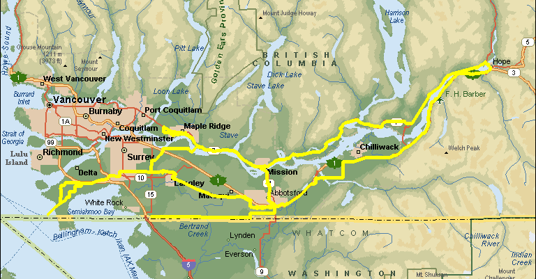
Lower Mainland Spring 600 Saturday/Sunday, June 8&9, 7:00 a.m. Start/Finish: Abbotsford (& Réal Préfontaine & Manfred Kuchenmuller) |
|
(cum.) |
|
|
|
(int.) |
| 0.0 |
Park & Ride - Hwy#1 @ Hwy#11 |
|||
| 0.0 | L | W | Lonzo avenue to Vedder Way | 0.3 |
| 0.3 | BR | N | Vedder Way to Marshall | 0.5 |
| 0.8 | L | W | Marshall Road to Riverside Drive | 0.1 |
| 0.9 | L | S | Riverside Drive to King Road | 0.6 |
| 1.5 | R | W |
King Rd to Townline [At Clearbrook Rd quick R & L & SO] |
6.5 |
| 8.0 | R | N | Townline Rd (becomes South Fraser Way) | 3.8 |
| 11.8 | R | N | Mt Lehman Road | 0.1 |
| 11.9 | L | WNW | Fraser Hwy | 20.8 |
| 32.7 | R | N | 206 St (becomes Logan Ave.) in Langley | 0.3 |
| 33.0 | R | N | Glover Rd - to Mufford | 1.1 |
| 34.1 | L | W | Mufford Cr - becomes 64 Av | 0.8 |
| 34.9 | SO | W | 64 th Avenue to 132 St | 14.9 |
| 49.8 | L | S | 132 St to Hwy # 10 | 1.2 |
| 51.0 | R | W | Hwy 10 to Harvest Drive | 15.8 |
| 66.8 | L | S&W | Harvest Dr bceomes 44 Ave at Arthur Dr. | 1.6 |
| 68.4 | L | S | Arthur Dr to 28 Ave | 3.3 |
| 71.7 | R | W | 28 Av to 52 St | 0.2 |
| 71.9 | L | S | 52 St to Hwy 17 | 1.8 |
| 73.7 | R | W | Hwy 17 to Ferry Terminal (Passenger) | 5.0 |
| 78.7 |
BC Ferries Terminal |
|||
| 78.7 | TA | NE | Hwy 17 to 28 Ave | 7.6 |
| 86.3 | R | E | 28 Ave to 64 St | 0.8 |
| 87.1 | L | N | 64 St to 36 Ave | 1.6 |
| 88.7 | R | E | 36 Ave to 72 St | 1.6 |
| 90.3 | L | N | 72 St to Churchill (Boundary Bay Airport) | 1.5 |
| 91.8 | R | E | Churchill St to 80 St | 1.5 |
| 93.3 | L | N | 80 St to Hwy 10 | 0.8 |
| 94.1 | R | E | Hwy 10 to 132 St | 11.3 |
| 105.4 | L | N | 132 St to 64 Ave | 1.2 |
| 106.6 | R | E | 64 Ave to 176 St | 8.6 |
| 115.2 | L | N | 176 St to 80th Avenue | 3.3 |
| 118.5 | R | E | 80th Avenue | 1.1 |
| 119.6 | L | NE | Harvey Road becomes 192 St to 96 Ave | 4.1 |
| 123.7 | R | E | 96 Ave to Glover Road | 8.4 |
| 132.1 | L | N | Glover Road to Ft.Langley Ferry dock | 1.7 |
| 133.8 | R | E&N | Albion Ferry dock River Rd/240th St. to Hwy 7 | 0.5 |
| 134.3 | L | NW | Highway#7 (Lougheed Hwy.) | 2.9 |
| 137.2 | L | NW | Haney Bypass | 2.5 |
| 139.7 | L | W | Highway#7 (Lougheed Hwy.) | 6.3 |
| 146.0 | L | S | Harris Road | 0.1 |
| 146.1 |
McDonalds Restaurant 12549 Harris Road |
|||
| 146.1 | CO | S | Harris Road | 1.5 |
| 147.6 | L | E | Hammond Road | 1.6 |
| 149.2 | L | N | Maple-Meadows Way | 0.1 |
| 149.3 | R | E | Dunn Avenue | 0.3 |
| 149.6 | R | S/E | West Street (becomes Hammond Road then Maple Crescent) | 1.1 |
| 150.7 | BL | E | Westfield Avenue | 0.6 |
| 151.3 | L | N | 207th Street | 0.3 |
| 151.6 | R | E | River Road | 3.5 |
| 155.1 | BR | SE | Haney Bypass | 1.9 |
| 157.0 | BR | E | Highway #7 (Lougheed Hwy.) | 101.9 |
| 258.9 | L | S | Highway #1 (Water Ave. in Hope) | 2.5 |
| 261.4 |
Chevron Service Station Water Ave. @ Hudson Bay St. |
|||
| 261.4 | CO | S/W | Highway #1 (Water Ave. in Hope) | 55.5 |
| 316.9 | L | S | Lickman Rd (Exit #116) | 4.6 |
| 321.5 | R | W | Keith Wilson to Boundary Road | 5.4 |
| 326.9 | R | N | Boundary Road to # 2 Road | 0.2 |
| 327.1 | L | W | # 2 Road to Interprovincial Hwy | 2.1 |
| 329.2 | L | S | Interprovincial Hwy to # 3 Road | 1.5 |
| 330.7 | R | W | # 3 Road over Freeway to North Parallel Rd | 1.5 |
| 332.2 | BL | W | North Parallel Rd/Atkinson/Eldridge to Whatcom Road | 9.2 |
|
|
||||
| 341.4 | SO | W&N | Cross Whatcom & continue N. Parallel to Old Yale | 1.3 |
| 342.7 | L | WNW | on Old Yale to Delair | 0.6 |
| 343.3 | L | W | Delair to Hwy 11 | 2.2 |
| 345.5 | L | S | Sumas Way (Highway #11) | 0.2 |
| 345.7 |
Bakerview Inn |
|||
| 345.7 | R | S | Sumas Way (Hwy # 11) to Vye/Huntingdon Rd | 2.0 |
| 347.7 | R | W | Vye Rd/Huntingdon to Townline Rd | 7.0 |
| 354.7 | L | S | Townline Rd to 0 Avenue | 1.6 |
| 356.3 | R | W | O Avenue to Hwy.#13 | 9.2 |
| 365.5 | SO | W | 0 Avenue/176A St/1st Ave to 176 St | 18.7 |
| 384.2 | L | S | 176th St. (Hwy.#15) | 0.2 |
| 384.4 |
Canada Customs |
|||
| 384.4 | T | N | 176th St. (Hwy.#15) | 0.2 |
| 384.6 | R | E | 1st Ave/176A St/0 Ave | 27.9 |
| 412.5 | L | N | Townline Rd to Vye Huntingdon | 1.6 |
| 414.1 | R | E | Vye Rd/Huntingdon to Hwy # 11 | 7.0 |
| 421.1 | L | N | Hwy # 11 to Lonzo (Bakerview Inn) | 2.0 |
| 423.1 |
Bakerview Inn (Food available at Chevron at Marshall Rd) |
|||
| 423.1 | L | N | Sumas Way (Highway #11) | 0.2 |
| 423.3 | R | E | Delair Road | 2.2 |
| 425.5 | R | SE | Old Yale Rd. | 0.6 |
| 426.1 | R | S/E | North Parallel Rd | 1.3 |
| 427.4 | R | S | Whatcom Rd | 0.2 |
| 427.6 | L | NE | South Parallel Rd | 9.3 |
| 436.9 | R | E | #3 Road | 0.9 |
| 437.8 | L | N | Interprovincial Hwy | 1.5 |
| 439.3 | R | E | # 2 Road to Boundary Road | 2.1 |
| 441.4 | R | S | Boundary Road to Keith Wilson | 0.2 |
| 441.6 | L | E | Keith Wilson to Lickman Rd | 5.4 |
| 447.0 | L | N | Lickman Rd to Hwy # 1 | 4.5 |
| 451.5 | R | E | Hwy # 1 | 54.8 |
| 506.3 | BR | E | Exit #170 | 0.4 |
| 506.7 | L | NE | Highway #1 (Flood-Hope Rd/ Water Ave. in Hope) | 0.8 |
| 507.5 |
Chevron Service Station Water Ave. @ Hudson Bay St. |
|||
| 507.5 | CO | N | Highway #1 (Water Ave.) | 2.5 |
| 510.0 | BR | E/W | Hwy # 7 ( becomes 1st Ave. in Mission) | 79.9 |
| 589.9 |
Tim Horton's Donuts 33291 1st Ave. |
|||
| 589.9 | T | E | Highway #7 (1st Avenue) | 0.2 |
| 590.1 | R | S | Murray Street (to Abbotsford over RR tracks) | 0.2 |
| 590.3 | L | SE | Horne Street | 0.1 |
| 590.4 | BR | W | Highway #11 (feeder road) | 0.9 |
| 591.3 | BL | W/E | Highway #11 (through tunnel & over bridge) | 2.2 |
| 593.5 | BR | SE | Matsqui Exit | 0.5 |
| 594.0 | BR | S | Riverside Road | 3.0 |
| 597.0 | L | E | Townshipline Road | 0.5 |
| 597.5 | R | S | Riverside Road | 0.8 |
| 598.3 | L | E | Clayburn Road | 0.1 |
| 598.4 | R | S | Highway #11 (becomes Gladys Ave. in Abbotsford) | 3.7 |
| 602.1 | R | W | Essendene Avenue | 0.1 |
| 602.2 | L | SE | W.Railway Street | 1.0 |
| 603.2 | L | SE | Riverside Road | 0.8 |
| 604.0 | L | E | Marshall Road | 0.1 |
| 604.1 | R | SE | Vedder Way | 0.5 |
| 604.6 | L | E | Lonzo Avenue | 0.3 |
| 604.9 |
Bakerview Inn |
|||
| Note: This is not the official route sheet. Ride organizers may make last minute changes because of road closures or other problems. The route sheet you receive at the start of the ride is the official one. | ||||
o