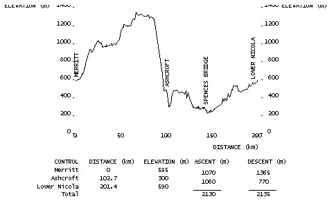
|
|
|
|
(cum.) |
Turn | Direction | Route Description |
(int.) |
|
7-11 Convenience Store SE corner Voght St. & Nicola Ave |
||||
| 0.0 | L | W | NICOLA AVENUE(HWY. #8/97C) | 4.8 |
| 4.8 | R | N | HIGHWAY #97C(MAMIT LAKE RD) | 42.0 |
| 46.8 | L | W |
HIGHWAY #97C (HIGHLAND VALLEY ROAD) |
55.5 |
| 102.3 | BL | W | 1st STREET | 0.2 |
| 102.5 | L | S | RAILWAY AVENUE | 0.2 |
| 102.7 |
Secret Garden Restaurant |
|||
| 102.7 | T | N | RAILWAY AVENUE | 0.2 |
| 102.9 | L | W | 1st STREET (Ashcroft Bridge over Thompson River) | 0.4 |
| 103.3 | L | S | CORNWALL ROAD | 3.3 |
| 106.6 | L | S | HIGHWAY #1 | 38.3 |
| 144.9 | L | S/W | RIVERVIEW AVENUE EAST | 0.8 |
| 145.7 | L | S |
BRIDGEWAY ROAD (over Thompson River) |
0.3 |
| 146.0 | L | E | HIGHWAY #8 | 55.4 |
| 201.4 |
Courtesy_Corner_Grocery_Store |
|||
| RETURN TO START | ||||
| 0 | CO | E | HIGHWAY #8 | 8.6 |
| 8.6 | 7-11 Convenience Store (SE corner Voght St. & Nicola Ave.) | |||
| Note: This is not the official route sheet. Ride organizers may make last minute changes because of road closures or other problems. The route sheet you receive at the start of the ride is the official one. | ||||