| Newsletter - 2023 Archive |
Cycling Club |
 |
| Newsletter - 2023 Archive |
Cycling Club |
|
Next--->
|
Whidbey Whander 600 On May 27th, 2023, a select group of top BC Randos met at a 7-Eleven on Fraser Street for the start of organizer extraordinaire Etienne Hossack's Whidbey Whander 600. We gave the crew our drop bags, heard some opening remarks and were off. For years now I have focused on a Super Randonneur series as my rando output for the year, with a sub-24 hour time on the 600 as my top goal. This has been made easier in years past because we had a series of easier 600s starting in 2020 due to Covid-19. The hillier and more windy terrain of Whatcom and Snohomish counties has been closed off for that entire time, and by necessity the club has done a lot of rides in the "Loopy Valley Spaghetti" style, designed primarily for easy self-support and generally without much climbing. Well... the club had come roaring back in 2023 with Whidbey Whander, a genuinely sorta-hard Spring 600 that actually goes somewhere. Perfect! But it made getting under 24 hours a relatively tall order. I was riding a borrowed Fairlight Secan, set up with bikepacking bags: a half framebag for calories, rando paperwork and basic tools; big Revelate seatbag for "advanced" tools and clothes, and top tube box for loose gummy bears, sunscreen, a USB power source and drugz (caffeinated nuun, straight up 100mg caffeine, Advil). The bike was set up with tubeless Conti GP5000 tires without fenders, Ritchey Sliver aerobars and my mismatched 46-30 power meter chainset, as well as a completely redundant pair of battery and dynamo light systems. 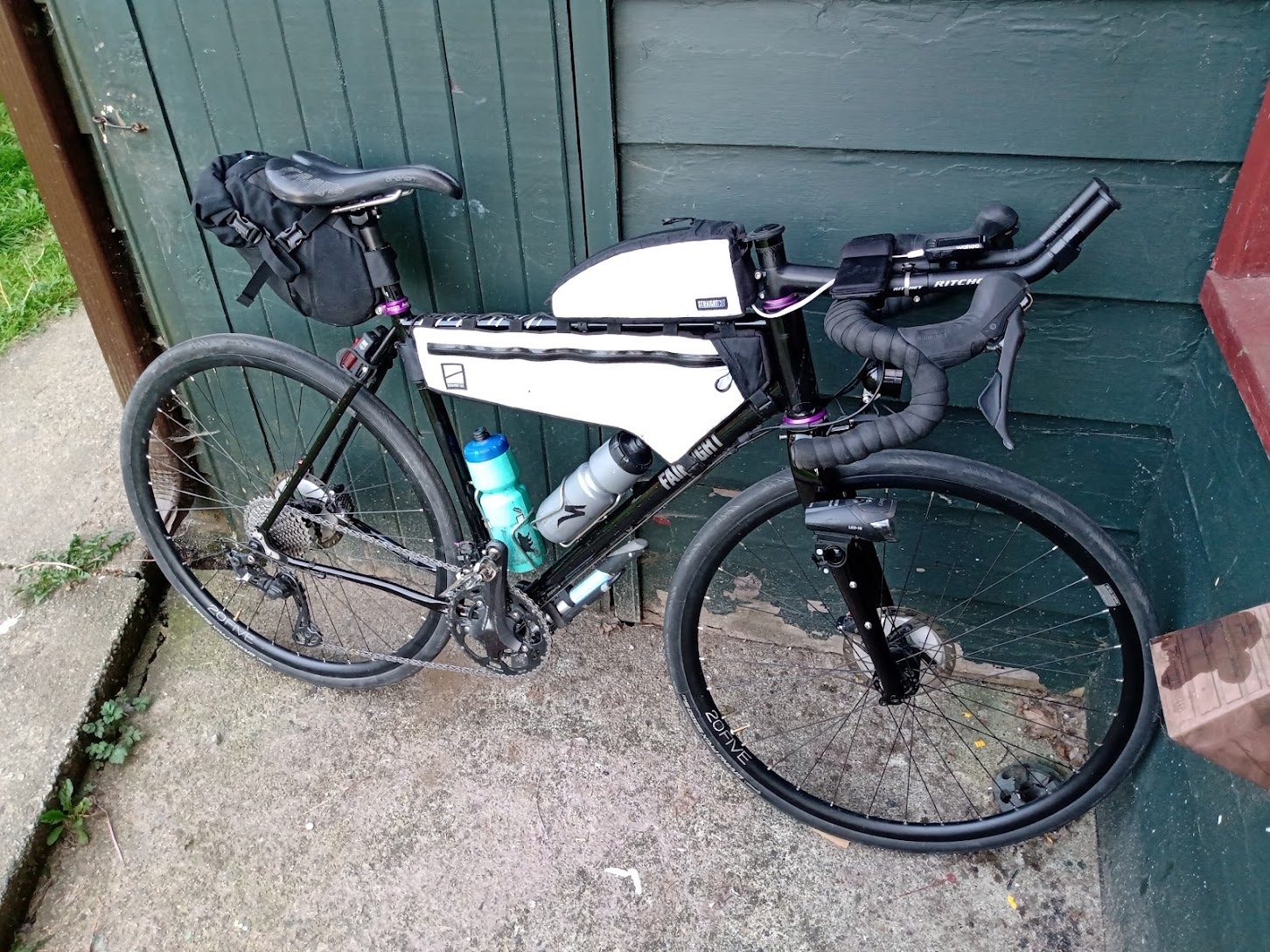 I was carrying eight Boost Plus, and also a cup of white sugar mixed into a single bottle with a caffeinated Nuun tablet, aka "Garbage Water". This was my first big ride with white sugar so I wasn't relying on it as a primary source of calories. I needn't have worried though as it worked great. White sugar is getting some buzz on the internet as an easy source of evenly mixed fructose and glucose, which is what you're supposed to have in order to hack your digestive system into accepting more carbs per hour. I did find that my bottle of Garbage Water was more than enough to make it 80 kilometers or so and will definitely be incorporating more sugar in the future. The entire group hung together down Fraser Street, across the Millennium Line overpass and through Richmond, but split decisively at the Alex Fraser bridge over to Delta. Chris Cullum and I headed off the front, chatting through the wild and bushy "Upper Pathway" around Burns Bog. On one of the connections for this path, though, we had a moderately disastrous crash! It happened when the two of us were headed up Kittson Parkway for a couple of blocks, looking for a right turn up onto the curb and through some bushes onto the continuation of the trail. I spotted the turn and called a right, but Chris was distracted by his GPS alert for the turn and I got rear-ended. The crash made a terrible noise but Chris, his bike and my bike seemed totally unhurt; after checking up on him we continued on. I was shook and didn't like what had happened; I had been in a very similar situation as the following rider earlier this year coming down Grant McConachie Way. The scenario is, riders on a fast bit of asphalt are looking to the right for a connection with a small, hard-to-see trail. GPS alerts distract following riders, and so when the lead rider finds the turn and slows there is a decent possibility of a rear-ender crash. I will think about that kind of thing in the future and take steps to avoid it. Chris and I continued across Colebrook and up King George to the border. We passed through easily and saw tandemists Nigel and Deirdre there before heading on our way. Just up the road into Blaine, Chris suddenly noticed a nasty tube bubble poking from his front wheel. Something was very wrong and he was close to getting a front wheel blowout. We stopped immediately and figured out that the crash had bent his Granville's fork blades backwards. His brake pads were rubbing the tire and had worn a hole already. Luckily I had a piece of tyvek from a trusty old Sun Run number tag, and his brakes had a bit of room in the slots to get aligned. Chris resolved to try and finish the ride with his bent fork and get a new tire in Bellingham at the Trek store, conveniently right on the route. While we sorted this out I had lost a bit of time, and first the tandem and then Michael Gottlieb had passed our group. I figured that I had to get going if I was going to hit my 24 hour mark, as so far the average was down around 21 km/hr with an hour and a bit into the ride. Getting under 24 hours means maintaining an average speed of 25 kilometers per hour---not that easy to do all day and night, through all kinds of stuff happening, but that's exactly why I love trying to do it. So I got into the aerobars, said bye to Chris and Michael, and headed through a galaxy of windblown cottonwood puffs around Drayton Harbor. Around this time I figured out that both my power meter and HR monitor had stopped working and likely weren't going to come back. I resigned myself to having to use the force, AKA perceived effort, to moderate my output all day and night. This wasn't a huge setback - I like to think my PE is better tuned than it used to be. But it didn't make the job easier. No big deal though! The wind was blowing, traffic was light and the bay was just really pretty. I rolled through the first info controle, writing my answer without stopping, and headed round more lovely sections of Birch Bay. It was just great to be back in Whatcom County after years away. Before long I headed into the gentle climbs up to Mountain View, then down towards Lummi Nation and the road to Bellingham. Pulling into Bellingham itself I found to my satisfaction that my average speed was back up at 25 km/hr, and also found Nigel and Deirdre on the tandem. We chatted through Bellingham and out to the day's second controle at Fairhaven. By this time I was out of garbage water but still flush with Boost, so just bought a big bottle of Crystal Geyser water, which I split with the tandem crew. Average speed was dropping fast with this time spent at zero km/hr, so I said goodbye and headed into the Chuckanut hills. Chuckanut Drive was perfect. I was not hammering the hills, just doing everything including flats and downhills at moderately zesty Zone 2. So I had lots of space to enjoy the sound of wind, smell of the dry pine trees and view after view. Before long, I was heading quickly across the flats through Edison, down to Bay View, and west towards Whidbey itself. In spite of a pretty stiff headwind, I was able to scrunch myself into a small shape on the aerobars and make decent time in Z2. The ride up around March Point was great, in spite of huge and somewhat dystopian refineries. The history of industrial activity in this area had created the Tommy Thompson Trail, a converted rail crossing over Hidalgo Bay that is now just ridiculously scenic. 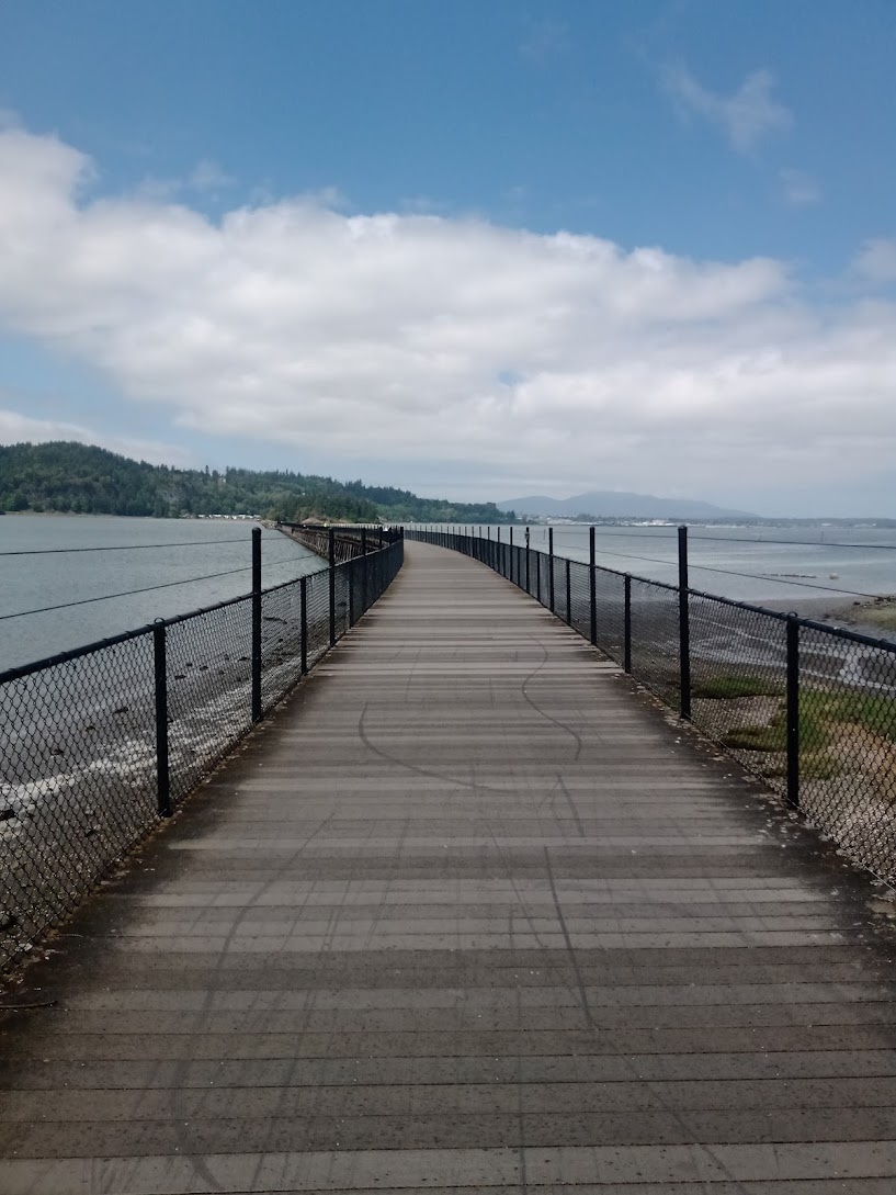 The trail connected directly to rail trail up to Anacortes. And here was another controle, riders' choice. Not wanting to deal with randomized 7-11 food as recommended on the cuesheet, I hit the Anacortes Walgreens instead, hoping for another sixer of Boost Plus... and found it! It was American boost, in plastic bottles instead of our trusty Canadian tetrapaks; but every bit as calorie laden/ mildly gross. Inside the Walgreens I discarded empty boost bottles into a trash can, loaded the Fairlight's framebag and my jersey pockets with the next six, and hit the road. I quickly realized that while I had been stopped, it would have been a good idea to get water filled up too; but didn't want to stop at any store to fix that as time was wasting. No problem though, I still had a complete bottle and lots of time to look for a tap. This was around the time that the route started to get seriously hilly, but no part of it was really that terrible. Just a big series of pretty suburban harbors with steep descents down, and equally steep climbs back up, out of Anacortes and into Rosario Beach. Before long I was on Highway 20 and heading across the lovely Decepticon Pass bridge which was absolutely packed with auto and foot traffic for the Memorial Day long weekend. No one wanted to move too fast; everyone was taking tons of pictures, so it made for chill cycling in spite of all the cars. At the end of the bridge I noticed a huge set of park washrooms on the right with no lines; perfect to fill up my bottles fast! So I did, adding more caffeinated Nuun, and soaked my arm coolers and necktube too as it was getting a bit hotter. From here there was an eleven kilometer run on the main highway, a lot faster going than the hills of Anacortes and Rosario. I picked up more average speed here, which was good because I had lost time grinding up all those hills. Before long I had made it to Ault Field Road, with a bit of time to spare. The big military installations of Ault Field were part of a recurring theme of the day's and night's ride, along with huge refineries and endless little harbors and farms. I had set my GPS to say "FOOD" every 45 minutes and found it really useful for keeping nutrition on track; my old hourly schedule was always just a little bit too little, and I would tend to get quite behind on calories after ten hours or so. And here in this spot I remember chugging FOOD in the form of a full Boost. I made it around another series of quiet pretty hilly roads up onto Highway 20 again, enjoyed more free speed, and headed down for the right hander towards Ebey's Landing National Historical Reserve. I found the descent to Ebey's Landing with quaint farm houses on either side impossibly pastoral, almost like a dream or a visit to the afterlife. The bay itself was crowded with Memorial Day traffic but also full of the most beautiful sound of waves hitting the long crescent shaped beach. That was just too much. Coming up from Ebey's Landing were amazing pine trees that had been repeatedly blown diagonally by powerful winds, then grown up again, so that their trunks formed a trippy, Seussian zig zagging pattern. For me, the entire sequence down to and up from Ebey's Landing was the highlight of an incredible route. After Ebey's, on the aerobars, and at a ways past 30 km/hr, I hit a patch of sand by the side of the road that was quite a bit deeper and softer than I assumed. Very nearly ate shit but luckily I did not. Taking that damage would have made the rest of the day and night quite a bit tougher. Thank the rando gods. Out of Ebey's, and down to the Port Townsend ferry terminal I went. This was another super fast section. I had planned to stop at the ferry terminal to fill bottles but there was no need; it just wasn't that hot out, only mid 20s in metric. That was lucky as just a few weeks ago we had had a mini heat wave. After the ferry terminal was a long flat stretch with a sweet tailwind; getting to cruise at over 40 kilometers an hour put some time in the bank. With my average speed up past 26 kilometers an hour I began to entertain fantasies of finishing under 23 hours. As the route wound down Highway 525 and into Smugglers Cove Road this dream solidified. I was making quite good time and felt great. Well, the dream evaporated after the gas station controle at Clinton. I took a bit of extra time here due to a last-minute decision to go back in to get extra candy (It wasn't needed, I had just lost track of how much stuff I had left and got paranoid). Between that and the difficult terrain to come, it became clear that getting under 24 hours would be quite hard enough. Heading up to Langley, things got pretty hilly but no less scenic than they had been all day. Langley (like Freeland and a bunch of other places along this route) is a cool hippie town full of nicely kept heritage houses; between that and some of the trumpy neighborhoods I passed through with thin blue line flags and the like, I feel like I got a pretty good cross section of the PNW citizenry. I was still not near sunset; wind was cooperating but the terrain was just really hard to make good time on. Time after time the route turned right, down a steep hill to a pretty beach; and then left, out of the harbor and up an evil grade. I didn't have my Wahoo keeping numerical score of grades but it did feel like there were lots of times that I hit fourteen to seventeen percenters. On one slope I found later that my zigzagging showed up on the RWGPS track: my suffering visible from space. 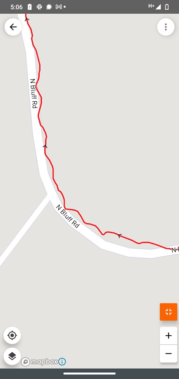 Overall in this ride I felt like I didn't have enough low or high gears; on lots of the extended downhills I spun out my 46-11, and the steepest climbs were a 40 RPM grind with 30-34. I focused on not freaking out and going too hard on any of the climbs, while maintaining pedal pressure on every downhill instead of just coasting. Z2 all the time. Turn after turn, climb after climb, beach after lovely driftwood beach, I made it up to Oak Harbor and Cheryl and Andrew's controle in Oak Harbor. I had borrowed Etienne's Garmin Connect and Cheryl and Andrew had been watching my dot, so they were ready to wave me in. There I loaded up with nine Boost, an apple turnover and a cup and a half of sugar in one bottle; just about enough to make it the rest of the way through the course. I also got to wash my filthy hands and hog a couple slices of pizza. Cheryl and Andrew made sure I had enough layers (seatbag was well stocked, so I was fine) as it was going to be cool through the night, and I headed out with average speed right around 25.1 km/hr. So I was on schedule but barely, and needed to make it all night with very little going wrong. I was super happy to figure out that all the very tough climbing was finished. Even though the remainder of the route had climbing, there were no more evil pitches and it was just easier to keep speed. Winding out of Oak Harbor I passed a military cemetery with every grave decorated with a little American flag, which later Googling revealed to be the main idea of Memorial Day. The sun set and I got ready for the short night, enjoying the fact that the Spring 600 is really close to solstice. The route wound around a bunch more pretty harbors, now moonlit, and uphill into the night. I put on my raincoat at the night's last info controle at the Rider's Memorial down by the Skagit River, as it was definitely getting chillier. From here it was a quick, not terribly windy ride up to Burlington (nothing needed here) and then the AM-PM at Sedro-Wooley, a legendary BC Randos night spot that I had not been to since before 2020. This was the ride's final non-info controle, and I headed in to buy some more water along with a couple Snickers and gummies even though they were not really needed. From here I moved up into the hills of Sudden Valley (a location that will forever remind me of that "Arrested Development" plot line) and enjoyed several beautiful moonlit lakes. A quick descent through Bellingham, up through Mountain View and back down into Birch Bay, and one more info controle (I had cheated and spotted the answer on the way out, in daylight, but did write my answer at night) Heading through the 3 AM witching hour I was chewing Wake Ups and sleepy but not falling asleep; I knew I would survive all night. I made it through the border crossing in good time, and was happy to talk to the guard and have a little Canadian contact after spacing out on the aerobars all night. After crossing the border I was right at 25.1 kilometers per hour. I knew I needed to step on it over King George and Colebrook because the woodsy Delta pathway and the Alex Fraser Bridge were going to be slow. So I did. I made it with no flats or any other drama, passed into the woods as it was getting light, and enjoyed a rather amazing pink sunrise over the Alex Fraser (sorry about this fuzzy photo) 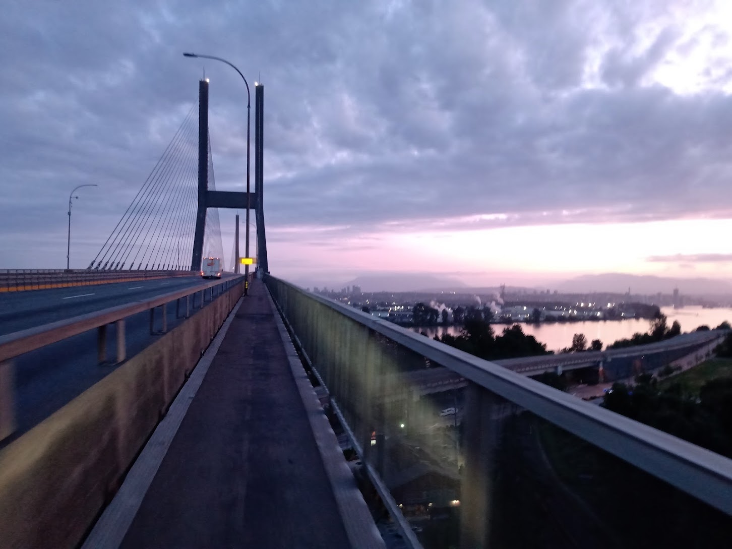 I was still at 25.2 km/hr as I headed into Richmond and up River Road. My legs were shattered, glasses extremely smudged, clothes super dirty, skin crusted with salt; but really pleased as it became clear that I was probably going to make it. Absolutely nothing bad happened going over the Millennium Line overpass back into Vancouver and up the hill towards the finish. I even had a bit left for a nano-sprint at the very end. When my GPS finally said "Arrivee" I headed to JJ Bean for breakfast and then into a painful and very drowsy 17km slog back out to Port Moody---the Skytrain wasn't running yet and adrenaline had run dry---and sleep. Hooray, another 600 in the bag!
Go to:
Event Page (Database) June 8, 2023 |