| Newsletter - 2017 Archive |
|
|

|
Cycling Club |
|
|
| Newsletter - 2017 Archive |
|
|
|
Cycling Club |
|
|
Next--->
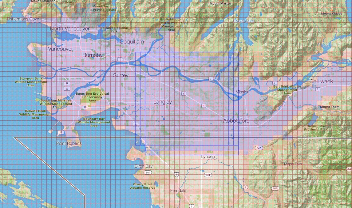
And Herein Lays A Tale . . . “Hello, my name is Mike. I’m a tileaholic.” “Eh? You want to know what a tileaholic is?” “Well, it’s an addictive, compulsive, and obsessive behavior pattern . . . I’m not sure I should tell you more; it might not be a nice thing to do to you.” “What? You want me to tell you? You insist? Well, okay . . . but it’s on your head, not mine.” Many riders these days carry Garmin GPS cycling computers or have ride tracking apps on their phones. A lot of them upload their activities to Strava (“Facebook for Athletes!”). Strava summarizes and presents the details of one’s activity. Strava also breaks down courses into segments, and one can see how one has done on a segment compared to one’s friends or to any others who have done the segment. One might even be the fastest, the King or Queen of the Mountain. But, as it turns out, there is a lot more that can be done with Strava data. Enter Veloviewer! Veloviewer is Strava for data nerds. Veloviewer is Strava on steroids. Veloviewer is heaven for hard-core geeks who are also hard-core riders. Veloviewer calculates, presents, and displays Strava data in dozens of additional ways. I love Veloviewer! One of the most engaging things that Veloviewer does is to track the number of tiles one has crossed. Tiles are square-mile plots of land; the whole world is covered by a grid of one-mile squares. Tiles already existed, they are the underlayer on which Google Maps places their maps and satellite photos, but Veloviewer looks at one’s Strava data and keeps track of how many tiles one has crossed (or grabbed). Further, Veloviewer calculates the size of one’s Max Square (the largest square containing tiles that have all been grabbed), and one’s Max Cluster (the largest cluster of tiles one has grabbed that are each bordered by a tile that has also been grabbed). It’s addictive to scheme and plot routes designed to grab new tiles and build one’s Max Square or Max Cluster larger and larger. The thing is, once the easy, nearby tiles are grabbed, one has to go further and further afield or tackle roads that are, let us say, less than optimal. This is not a problem, chasing tiles gets one onto new roads, alternate routings, and into places that one maybe didn’t realize existed. There are lots of surprises. All good! But as the ungrabbed tiles get further and further away, well, one might as well do the route as a permanent. And therein lays a tale: “Dr. Strange One, or How I Learned to Stop Worrying and Love Off-Route Side-Trips and Extra KMs”. Permanents are fun. Permanents are more versatile and flexible than brevets. One can choose when to ride a permanent, when to start, and what route to follow. If one of the existing routes (165, at last count) is not suitable, why, one can adjust the start/finish point of an existing route, or, if that’s not enough, one can create one’s own route. Further, alternate routing is fine. Want to go a slightly different way? Just let permanent co-coordinator, Eric Fergusson, know in advance, and off you go. I used to ride permanents the way I ride brevets: fast, with an eye on the route (flat, smooth roads; few stops; tailwinds!), minimizing stoppage time, trying to get to the finish quicker than before. But no more. Now, I’m looking for or creating permanents that get me to tile-grabbing territory. I’m looking for alternate routing to grab tiles. Gravel roads? Steep climbs? No problem: just put the gravel tires on the bike and go. That’s the way I rode three permanents in September. On The Border, September 21 This route goes from North Burnaby over the Alex Fraser Bridge to the first control at the Campbell River Store; along 0 Ave to Sumas, Boundary Rd to Whatcom Rd, and north on Cole Road to the second control at the Yellow Barn; and returns to North Burnaby via Abbotsford, Fort Langley, and Coquitlam. I had a few ungrabbed tiles along the border in Abbotsford and on Sumas Prairie, so this was the ideal way to pick them up. I rode this permanent with Kevin Bogle. Eastbound 0 Ave ends at Townline and one goes north to continue east on 8 Ave/Huntington Ave, so side-trips south on Clearbrook, Gladwin, and McCallum were needed to grab missed tiles. Did you know that there is a large pumpkin farm on Clearbrook Road that is a hive of activity this time of year? Full parking lot, school groups, lots of happy noise and excitement? Yeah, neither did I. After hitting the border on McCallum, we went east on Farmer to Riverside. Farmer is a nice alternate to Vye Road (especially if one is travelling west; the climb up Vye being what it is). After getting back on Vye at Whatcom after Sumas, we went off route again on Lamson to pick up the border tile. We then took Maher Rd, which becomes Old Yale Road, and is a nice alternate route south of Vye Rd. It beats the everlasting railway embankment and traffic on Vye. Old Yale Road carries on beyond the corner of Vye and Powerhouse Road though it dead-ends at “No Trespassing” and “Beware of Dog” signs uphill after the railway track crossing. Tile grabbers get used to that. Just four more tiles to grab. They were along Dixon Rd with an out-and-back for a kilometer on Campbell Rd and a 200 m shot down No. 5 Rd. And there it was; mission accomplished. I’ve done On The Border in under seven and a half hours, but not this time. It took almost 11 hours though there was 25 km of extra distance on the side-trips and alternate routing. Elf Stomper, September 24 Elf Stomper is one of two permanents that run up the Lougheed Highway from Vancouver to the Harrison Mills area. The other is Sasquatch, which routes via the Mary Hill Bypass and turns around at the Sasquatch Inn. Elf Stomper routes via the Barnet Highway and turns around at the Kilby Historic Site. Both routes feature long stretches of Lougheed Highway, but thanks to tile grabbing, I explored some alternate roads. Just east of Hatzic, I turned south off the Lougheed onto McKamie Road, which is opposite Sylvester Road. I had tiles to grab down Newton Road and River Road South at Dewdney Regional Park, but McKamie is an alternate route to the Lougheed. It’s longer, but it’s quiet. It returns to the Lougheed via River Road South, passes the historic Dewdney Pub, and rejoins the Lougheed just north of the bridge over the Nicomen Slough. About two kilometers further east, I turned right onto Nicomen Island Trunk Road. Now, if you have a honking tail wind, traffic pulling you along, and are hunched over your aerobars fixated on a PB on that Strava segment, then fine. But Nicomen Island Trunk Road is quiet and meanders alongside farms with birds fleeing from the hedgerows as you pass. Very peaceful. After eight kilometers on Nicomen Island Trunk Road, it is tempting to turn right onto Dyke Road and continue another nine kilometers to Malcolm Road, which Google Maps suggests is a good route. It’s not. Dyke turns to gravel very shortly, and is gated at Sterling Road in any event: Dyke is a two-track dirt road after that. Sterling is gravel most of the way back to the Lougheed, so it’s best to stay on Nicomen Island Trunk Road. After heading east to Kilby and getting my card signed at the turnaround control, I returned to Deroche and straight onto the North Nicomen Road. Yes, to grab tiles there, and, no, I’d never been on that road before. It’s a quiet road, but turns to gravel after a couple of kilometers at Clerihue Road. I pushed on another km to the end. There were cars parked there and a trail leading off. What about the other end? I’d always wanted to ride up Hawkins Pickle from Dewdney, and here was my excuse – tile grabbing! Hawkins Pickle is also a nice, quiet road. It goes almost four kilometers to a gate. Beyond the gate is a nature preserve: one crosses a bridge, and rides down old, broken pavement another half km to the end of the road. Again, a trail leads off. The gap from there to North Nicomen is about three kilometers but I suspect it is not rideable. While I was out there, I went up Bell, past the Inch Creek Hatchery, onto the Norrish Creek Forest Service Road, which is rough gravel. On my Trek, with 23 mm tires; yes, I got the tile; yes, insane. My fastest time on Elf Stomper is just over seven hours. This day took almost ten hours, but with 45 km of extra distance on the side trips and alternate routing. Out of Control, September 28 The compulsion continues. Tiles are getting harder to come by. There are a few in Mission I’ve missed and some up North Parallel along the southeast base of Sumas Mountain. What about Upper Sumas Mountain? Why not? For this route, I was going to need the gravel tires. So I designed a route to grab those tiles. Leaving from a favorite Rando corner, Boundary and Lougheed, accompanied by fellow tileaholic, Kevin Bogle, we drew a bead on Mt Lehman and off we went. I let Ride with GPS select the route. I’ve found that the Ride with GPS route building algorithms are actually quite good at finding pleasing routes between Point A and Point B. It sometimes messes up, or refuses to route along stretches that one knows are good cycling routes, but for the most part RwGPS does a good job of connecting dots. I’ve been directed onto roads or pathways that are superior to the routes I usually take. Getting to Mt Lehman, for instance, normally we would stay on 96th through Fort Langley and climb away from River Road on 240th. RwGPS suggested south on 216th, then Telegraph Trail, Glover Road, and Rawlison Crescent instead. That was a very nice route. I wanted to go along Townshipline between Bates and Riverside to cross tiles I’d missed so far in 2017. We went south from there the usual way through Abbotsford (Sumas Way/Gladys/ Delair/Old Yale) to get onto North Parallel. Looking forward to the tailwind, we pushed east on North Parallel to the bridge over the Sumas River at Atkinson Road, and picked up the Trans Canada Trail on the south dyke. This is gravel, but a very nice surface. There’s clearly been a fair bit of bike traffic as the stones have been knocked out of a riding lane down the middle of the trail. We probably saw more cyclists and people out walking here than anywhere else on the day. The trail tended to peter out the further east we rode, but seven kilometers later (after the MacDonald Park Dark Sky Preserve, the second in Canada when it was created in 2000) we came out again on North Parallel, and turned left to go another two kilometers to the end of pavement and Control #1. After admiring the car tire donut tracks in the turnaround, we headed back on North Parallel (Whee! Tailwind! Hitting close to 50 kph with the boost from truck drafts!) to Kilgard, turned right, and took a deep breath because here the climbing started. Kilgard went up, then Sumas Mountain Road went up, but it was only 12%. Pifft. Then we turned right on Dawson, and it went up, and up, and UP. Garmin said max grade was north of 22%. Sorry Kev. After Control #2 we whipped down Dawson, crossed Sumas Mountain, and continued down Dawson to Willet Road. North on Willet, the road climbed, and narrowed, and ended at the Girl Guide Camp. Was that an electric fence? To keep the boys out? Or the girls in? No, it wasn’t electric, just a fancy wire fence. And there was an adamant “No Trespassing” sign. No “Beware of Dog” sign, though. But it was Control #3, and we turned around there. Back now on Dawson the way we came, and left onto Sumas Mountain Road. Except now it was Upper Sumas Mountain Road. Decidedly “upper” as we climbed and climbed; but still got passed by tandem dump trucks enroute to the Highland Quarry. Why would there be a quarry on top of a mountain? Surely there are better places? Upper Sumas Mountain Road peaked at Batt Road, but Control #4 was up Batt. That meant more climbing, but not too bad at this point. We got to the control at the three-way corner of Batt, Bakstad, and Taggart where the pavement ended, but there was another tile up (yes, up) Taggart Road in Sumas Mountain Park. The first 500 m was good gravel, though uphill, then we got to the park entrance and the road, uh, deteriorated. It was rutted with loose stones the next 500 m to the mountain bike parking lot which marked the tile boundary. Note: “Mountain bike”, not “Road bike”. Nonetheless, we pushed up another hundred meters just to be sure. We were now almost 100 m higher in elevation than the turnoff from Upper Sumas Mountain Road. Getting down from Sumas Mountain Park was a bit dicey, but we made it. Back on the pavement, now going down (blessedly down) on Upper Sumas Mountain Road, the next challenge was going to be the gravel bit. My initial routing for this permanent had us going clockwise: Mission first, then Upper Sumas, then the TCT, and return through Abbotsford/Fort Langley. But Kevin suggested that tackling Sumas Mountain from the south was probably wiser. He was right. The gravel section started mildly enough. Though it was downhill, it was as good a gravel surface as one could wish for: hard-packed, almost pavement-like; few stones; very little washboard; no potholes. Taking it easy, it was going extremely well, then, with 500 m to go (the whole gravel section is 3.1 km long), things went downhill. Well, the road was already going downhill, but now the road became loose gravel, wash-boarded, and steep (a 200 m stretch is 30%). Thankfully there was no traffic, because I was using the whole width of the road to control my descent and avoid endos. If we had tackled Upper Sumas from the north, we would not have made it. Westbound on Page Road, on flat, quiet pavement, was blissful; only one challenge remained: a few hills in Mission. But now it was getting later in the day, and it was hot. Is this the end of September? Sure doesn’t feel like it. After climbing up Hurd, Cariboo, and Cedar to Control #4 at the Husky just before Dewdney Trunk Road, it was time for an ice-cream sandwich and a bottle of Gatorade – my go-to food on long rides. But first: get the card signed. That was iffy: the clerk acted like he’d never seen a cyclist before and had no idea of what a control card might be—he passed it on to his boss in a back room. Uh oh, the control card is out of my sight . . . but I got it back with the all-important initials. Here’s a routing through Mission that is very pleasing; it can be accessed off Dewdney Trunk Road if southbound from the Stave Lake dam for instance: west on Keystone then almost immediately bear left onto Clay. From Clay, carry on to Grove, and then onto Nelson. This is downhill and often swoopy. Just before the highway, turn right onto Silverdale Avenue. Silverdale is a nice undulating alternate to the Lougheed (Keystone is a great road too, so the routing choice here is a bit of a dilemma!). But we weren’t done with tile grabbing, so we turned right onto Lofton (more 20%), continued onto Gunn, and rejoined Silverdale after about 1½ km of extra distance. From there it was an easy roll along the Lougheed to the Pitt River Bridge and the Mary Hill Bypass back to the finish. This was the first time riding Out of Control, it took us 11 hours, 215 km (almost 20 km on gravel), and over 2000 m of climbing. Not sure that I will do it again. Perhaps others are adventurous enough. “What did you say? What’s next?” “Oh, well, there’re still a few tiles to grab in Chilliwack and up the valley towards Hope, but it’s time to push down into Washington.” “Yeah, probably going to do that soon. I’m planning a route now.” “What’s that? What’m I going to call the route?” “Well, you know I name all my routes after Eagles songs, and there is only one choice for this one.” “Frail Grasp On The Big Picture.” (Strava is at Strava.com. The BC Randonneur Strava Club is accessible from the Social Media tab on the club website. Veloviewer is at Veloviewer.com. A Pro account is about $17 to $20 per year depending on the exchange rate.)
Go to: Permanent Results -
October 6, 2017 |