| Newsletter - 2005 Archive |
|
|

|
Cycling Club |
|
|
| Newsletter - 2005 Archive |
|
|
|
Cycling Club |
|
|
Next--->
|
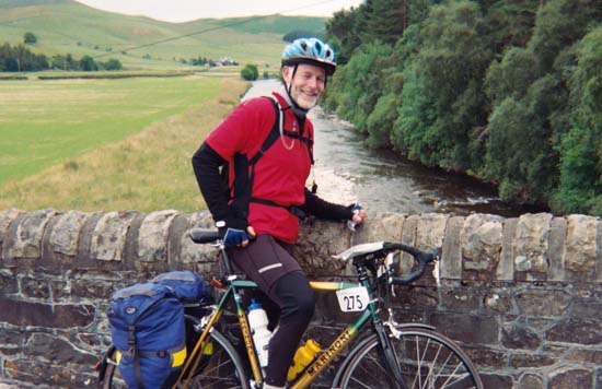
London-Edinburgh-London
2005 Introduction "The Year. 2005. 300 Cyclists. From five Continents. Rise to the Challenge. 885 Miles, Less than 5 Days. London to Edinburgh. Then back again. On a bicycle. Yes, Really! We know it's crazy. But we're doing it anyway. Everything is booked. We can't get out of it." So reads the text accompanying Damon Peacock's introductory movie clip on London-Edinburgh-London ( http://www.audax.uk.net/el/index.htm ) By the way, starring in the clip is BC Randonneur David Kirsop, rider # 69. Organized for the first time in 1989 and held once very four years London-Edinburgh-London (LEL) is one of those ultra-cycling events, which shows up on many a randonneur's wish list. I was intrigued by this 1,400 km event, which starts in Lee Valley/Cheshunt, just north of London for an out-and-back bike ride to Edinburgh, Scotland. It has to be completed in 116 hours and 40 minutes (or less), a time based on an average speed of 12 kph. This includes every second of down time. This spring I started thinking about doing another 1200 km ride, but wasn't sure yet which one. After contemplating GRR, Cascades 1200 and BMB, I finally settled on LEL. My goals were to (1) finish the ride in about 100 hrs, and (2) enjoy the British landscape, which meant riding as much as possible by daylight. Spring training included populaires (50, 100 and 150 km) and many short rides in between, followed by the 200 km and 300 km brevets. At the end of May I did the Vancouver Island 600 km followed by the Toronto 400 km a week later. In mid June I completed another 600 km, which brought my training close to the recommended plan for LEL. After that I reduced the volume, so that I would be fresh for the start. To get a sense of the route, I studied the detailed route instructions. There were 523 (!) directions over 1,417 km, which works out to one for every 2.7 km. It was obvious that the navigation skills had to be sharp to stay on the course. Traveling to Britain Left Canada on July 11 to first visit my family in the Netherlands. Did a bit of cycling, not much. Thursday July 21 I took the train from Deventer to Hoek van Holland, to catch a fast ferry - up to 70 kph -- to Harwich. There I connected with the train to London's Liverpool Street Station. Stena Lines had a steal of deal. For C$ 70.00 one could travel from anywhere in the Netherlands to London, not bad for three hours by train and another four by fast ferry across the North Sea. Beats the Eurostar price through the Chunnel. Yes, the catamaran ferry did work well! During the sailing we learnt that a series of bomb attacks in London had failed that same afternoon; the city was on high alert again. While disembarking in Harwich and boarding Rail One to London, there were no signs of alert. At London Liverpool station officials were very relaxed and above all very helpful to get me on the commuter train to Cheshunt. The Lee Valley Youth Hostel/LEL start was within 200 meters, so the trek with suit- and Ironcase was not too onerous. Friday morning
I assembled the bike and went to the on-site mobile bike shop
to have two new chain rings installed. The old ones had gotten
'short in the teeth.' The rings were installed free of
charge, courtesy of one of the LEL sponsors. Wonderful! While
chatting, the bike mechanic mentioned that he was contracted
by a London company on a permanent basis to maintain its employees'
bicycles. Upon my suggestion that Later on walked to downtown Cheshunt to
exchange Euros and cents for Pounds and pennies. Had lunch with
Tony Lonera from Italy and discussed LEL strategy, if there is
such a thing as strategy. Ha, as if only our minds are in control.
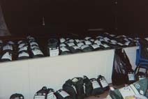
Registered that afternoon, filled my drop bag for the Hovingham
control (Km 381) and packed my panniers more than once.Nervous
ritual, stage fright? Still haven't quite learnt it after all
these years. The evening pasta dinner was a relaxed event; soon
everyone settled in for a quiet night. 1. Lee Valley (Km
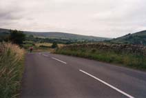
00) 65 km Most riders rose bright and early, enjoyed a good breakfast. Almost 200 riders started at Control #1: Cheshunt (Km 0) in blocks of 50 under cloudy skies. Rocco Richardson and Simon Doughty reminded us of two key things: (1) ride safely; take no risks; and (2) enjoy yourself! And with that we were off into the British countryside. Riding on the left side of the road somewhat tentative at first, but gradually growing more confident in tackling the many O's and mini O's (traffic circles); some 60 of them! Entering them against the grain - for non-British that is - was one thing, exiting quite another. It required fast unlearning an almost instinctive behaviour. We succeeded. The route took us through urban Cheshunt and its outskirts. The roads started to roll and wind, or to pitch and roll in sailor's jargon. Often that same road would be skirted by hedges and covered with tree canopies, creating beautiful verdant tunnels. The pace was steady, nothing like the mad dash and rush, so characteristic of the PBP start. The detailed route sheet may have contributed to this. Men and women hardened and wisened by experience, they were no fools. They knew the task at 'leg' - 1,400 km is a longer distance - and almost stoically we rode a manageable pace, at least in our group. There was ample opportunity to meet and greet fellow riders, make and renew friendships. Share and relive experiences from previous rides. Gradually we got used to the route sheets (eight pages in all; two columns per page). Using an odometer was no luxury for this event. In fact, it greatly eased the navigation, except in a few instances, where the paper route disagreed with reality. Some two and
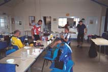
half hours later we arrived at Control #2: Gamlingay (Km
65), where volunteers greeted us with smiles, food and other
goodies. Within half an hour we were on the road again, gradually
leaving the hills behind us toward Control # 3: Thurlby
(Km 152). The walls inside the control were decorated
with drawings and flags of participating countries. These were
made by the primary school kids. A neat touch of community spirit.
After food and cups of Yorkshire tea we tackled the next leg,
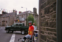
most Lincoln is a pretty sizable city with an impressive cathedral. It took a bit of city riding with all the traffic, before we were out of town. The route sheet caused a minor problem, but we were able to cycle our way out of the confusion. Not long after having solved that one, another obstacle: a work crew had blocked a level railway crossing. They couldn't tell us when it would re-open. After waiting a bit, we asked if we could use a narrow passage to cross the tracks; they agreed. We crossed, waited and regrouped. Then the pace picked up substantially. A tiny Welshman dragged us along in the fading evening light. Could he ever spin! Meanwhile the Italian contingent began singing Italian songs to cheer up one of their teammates, who apparently hit a low. While it wasn't vintage Paverotti, it did the trick. This was the spirit. Camaraderie at its best. Indeed "Memories are made of this," to quote from one of Dean Martin's songs. As we got closer
to Control # 5: Thorne (Km 298), we had to stop
and ask a few times for route clarification. It was dark by the
time we made it to the rugby club, where a few late night patrons
were still sipping their brew. How inviting to join, but the
plan called for another 84 clicks. Some riders called it a day
at Thorne, and planned to continue at dawn. Not a bad idea. After
restocking the body we left and cycled over a flat stretch that
did not leave any impressions, other than it was dark and we
were fast. Around Sand Hutton (Km 358) the terrain became
more undulating and road more winding. One of the Belgian riders,
whose bike was equipped with abundant lights and very detailed
route maps, set a grueling pace. Since route finding in the dark
was a bit of a challenge, we decided to hang on. We were flying
over those narrow country lanes; somewhere took a wrong turn,
but recovered the route to Barton le Willows ('le' stands
Day 2: Sunday July 24: Hovingham - Dalkeith/Edinburgh(326 km) 6. Hovingham (Km
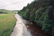
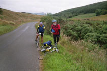
381) 80 km 'Woke- up' a little after 5:00 am. Many riders had already left, so the hall was less crowded. Breakfast went down a lot better than the food upon arrival. The morning was stunningly beautiful, very serene and peaceful. It felt great to get on the road again through this pastoral landscape with lots of sheep. First we tackled some pretty steep rollers, much steeper than expected. There were heaps in the berm; these had us guessing as to their origin, cause and purpose. No, they weren't road markers, anthills or disintegrating sandstone rocks. What could they be? So after a bit of scientific and non-scientific deduction, I figured/speculated/concluded that they must have been heaps of sand mixed with road salt to help motorist in the winter safely tackle the slippery slopes. We could have asked, I guess. The climb through Coxwold was challenging, but scenically rather rewarding. Soon we were in more open country on our way to Control # 7: Eppleby (Km 461). At that point we had covered about one third of the distance. We did not stay very long, then moved on toward the Pennine Chain, Britain's geological spine. This leg was quite pretty; we crossed the Tees River a few times and noted an increasing amount of road kill. The further North we went, the worse it got. The road was littered with dead rabbits, crows, magpies, hawks, rats, partridges, all kinds of rodents as well as hedgehogs, all unsuspecting victims of encounters with travelers of the other kind. We avoided the spiny leftovers of hedgehogs, because no-one was interested in multiple punctures. Many of the rabbits were totally flattened and dried-up, leaving no more than a thin sheet of 'bunny paper' on the asphalt. In our (my) sillier moments, I suggested they'd make fine souvenirs: 'From Scotland with Love.' Plain silliness of course, but that sometimes happens on long rides. The road kill however did remind me of an interview broadcast many years ago on CBC radio 'As It Happens', with a peculiar Brit and his extraordinary habit. The latter made him peculiar. I can't recall whether he traveled by car or motorcycle, but his habit was to scoop-up road kill, clean it, wrap in foil and place it on the manifold. He then kept on driving until it was done. The well-done, rare, medium or scorched morsels then became the carnivorous component of his supper. He recounted many tasteful, and less appetizing details of the raw status of the road kill as he picked it up - I'll spare the details. Pheasant was the only kill he wouldn't put on the manifold. This bounty he'd take home, string it up and let it cure until the head fell off. Only then would it be ready for the pot -- after further necessary culinary treatment of course - and eating. So the story went. While there was ample road kill between London and Edinburgh (and back) to feed all of us, none of us made use of it. No manifold on the bike! We passed the beautiful Barnhard Castle and gradually climbed our way up the spine toward Control # 7a: Langdon Beck (Km 503). Here they served yummy potato-and-leek soup, good coffee, sandwiches and fruit. Langdon Beck isn't much more than the youth hostel, a few distant and dispersed farms; a pub and a church, at least judging by the name St. John's Chapel. The countryside looked like one gigantic alpine meadow. Windswept grasslands with miles and miles of stone fences. It felt empty, remote and austere, yet the scattered farms in the valleys below, somewhat protected from the elements, and the sheep on the hillsides provided ample evidence to the contrary. There were stunning views, although somewhat subdued by the overcast skies that day. Wondered what a bright sunny day would do to this open space. Departing from Langdon Beck we headed for the summit at Yad Moss over a persistent 11 km climb, then descended over the next 15 km to Alston. There was a brutal 16% drop in the last 400 meters over a cobblestone road surface, including a 90 degree left turn as conclusion. We stopped briefly at optional Control # 8: Alston (Km 530), another youth hostel and then continued. Turned right at the war memorial and went up the hill on a section, which for a change required little route sheet reading for the next 28.8 km! Time to take the eyes of the odometer and enjoy the pretty scenery and rolling landscape. The winds had died, the cloudy skies opened and sunshine 'broke out'; temperatures rose. After Brampton the choice between a 'hilly route over back country lanes' or the 'heavily trafficked A6071/Longtown/A7 to Cannonbie' one. We opted for the latter, which on account of Sunday turned out to be a rather quiet route. Outside Longtown the winds picked up, to bother us until Control # 9: Cannonbie (Km 588). That control provided good food and offered a service with a personal touch. For a pound we'd buy a Cannonbie postcard and the control crew would mail it. Since the leg
from Cannonbie to Dalkeith was 119 km, LEL organizers had set
up an extra control after 53 km at Boston Hall near Ettrick.
This would then leave another 66 After crossing
the Esk in Langholm, we literally headed for the hills of the
Scottish Borderlands. A sense of remoteness and loneliness rested
in the landscape. We The stop here was brief, because we wanted to capture as much daylight as possible. The coffee, soup and other goodies did miracles. After we resumed, our speed increased substantially. We turned on to a narrow lane with several 'sheep guards' (cattleguards for sheep), which had to be crossed carefully. We conquered quite a few long climbs. It must have been past 11:00 pm, when we arrived at Innerleithen, still another 50 km to the turnaround. We had to clarify the route directions with local residents. They warned us about sheep on the road ahead. I couldn't help but remark that if we'd collide, it would be a soft and woolly landing, later on realizing that most sheep had been shorn - thus no soft landing!! For a moment I also wondered why in the land of plenty there was no mutton and red wine on the menu at the controls. Then again, come to think of it, we could have easily dropped in at a restaurant for such a gourmet dinner. Never thought of doing this. We were too occupied. Ah well, next time. After some 30 km in the Moorfoot Hills we came to a snow-gate. The route sheet read to go through, but the sign blocking the road indicated construction ahead and pointed to a detour. Lacking local knowledge about the state of the road and the nature of construction - who wants to possibly cycle 10+ km of gravel in the dark? So we decided to follow the official detour through Heriot. The detour added an extra 10 km to the 1,417 km brevet. Less than 1%, so what? We rapidly descended the dark and winding road; caution was the word and deed. We finally made it to the A7, which led us through Edinburgh's suburbs to Control # 10: Dalkeith (Km 707). Arrived at about 1:30 am Monday morning. Time for a shower, a meal and a sleep. The hot shower was great, so was the meal; what counted for 'sleep' left lots to be desired. The post had run out of cots and blankets, so the solution: find a spot and fend for yourself. It was not very warm. I found a spot, used a tiny towel as blanket. That did not work, so I put my Goretex jacket on, closed up every vent and zipper to keep the heat in, only to discover that this material has absolutely no R-value. I shivered and teeth-chattered myself through the rest of the night. Was I ever glad to get up for a hot breakfast. Day 3: Monday July 25: Dalkeith- Eppleby (247 km) 10. Dalkeith (Km
707) 66 km The next 60 km went via Brampton, Midgeholm, Slaggyford, Knarsdale in the Tyne valley to Alston, places which by the way look much bigger on the map than in reality. We picked Alston (Km 886) as Control # 12, so that Langdon Beck (Km 912) km) with its leek-and- potato soup became optional. Since I had picked Alston as optional on the way up, I ended with a stamp for every LEL control. The first 400 meter out of Alston was a real muscle burner. It includes a 16% grade and as insult to injury the cobblestones (Dutch: 'kinder-koppen'; Flemish: 'kasseien'). Grunted up this hill in my granny gear. The grade then eased off, but overall the road kept on climbing to the Pennine summit at Yad Moss. The weather remained cool and windy. Despite the climbing effort, I kept my windbreaker on; no luxury! At Yad Moss we began our descent, which did not require any effort: gravity took care of us. Since Alston was only 26 km behind us, we passed the optional control at Langdon Beck and just kept on sailing down through Middleton in Teesdale (very pretty), Mickleton, Romaldkirk, Cotherstone, and Lartington, across the Tees in Startforth. Here we went steeply down into the valley, negotiated a 180 degree hairpin, followed by a 90 degree left hook across the wooden bridge over the Tees. With only 10 km to go to Eppleby we must have misread the route sheet. Somehow, it did not make sense anymore: so close, yet so far. Sigh!! We waved down a farm service truck and explained our dilemma: our quest, destination and required route. The mechanic, who was intimately familiar with every lane and trail, got us back on track in no time. Another sigh, this time one of relief. One shouldn't be too shy to tap local knowledge. He drew a sketch map of our route. This made more sense than trying to absorb verbal directions like: go left, then right after the third corner........... Well, you know how that usually goes. During such explanation, (1) you nod in agreement; meanwhile (2) question marks rise in and above your head; (3) you are too polite to ask again for fear of sounding dim; then (4) you mumble 'I get it' and 'thanks' and depart, while (5) hoping for the best; and within minutes (6) you realize that you can't remember the details anymore. Oh, drat!! Now (7) you're stuck in the proverbial brown paper bag. Anyway, with the route sheet and the sketch map we made it to Control # 13: Eppleby (Km 954) by 9:00 pm. The original plan was to make to make to Hovingham (Km 1,034), where I wanted to be reunited with my drop bag. However I remembered that the Eppleby-Hovingham leg had 40 km of rather hilly terrain. After two days of challenging hills in the Scottish Borderlands, riding those lumps in the dark had lost some of its appeal. And, it also meant arriving very late in (if not early in the morning) in Hovingham. To stick to the original plan did not make sense anymore. I would be figuratively and literally losing sight of my objective to ride as much of LEL in daylight. Stopping in Eppleby would get me back on track. The other advantage would be an earlier and longer sleep, which did not seem a luxury at all. To continue or not to continue, that was the question. With more than enough time in hand, an executive decision was made to do the extra 80 km on Day 4. Called it a day, went for a brief walk in town and popped in at one - probably the only one - of the local pubs for one pint of Guinness. In the afternoon I had been wishing for a cool beer. I even 'saw people walking on the road all dressed up going out for a gourmet dinner'. Of course, there were none. Upon closer inspection these 'imagined people' were no more than traffic signs along the road. Meanwhile in the pub, I chatted with the only patron and the host about the meaning of all those bike(r)s in town, learnt about local concerns: crime, drugs and not enough police; in short crime and punishment. On the walk back to the control, one of the villagers stopped me and also asked about those cyclists; yet another opportunity to extol the virtues of randonneuring and LEL. By 10 pm I was horizontal in the very quiet of the control. Day 4: Tuesday July 26: Eppleby - Thurlby (311 km) 13. Eppleby (Km
954) 80 km Around 4 am the near dead became restless
and rose for a leisurely breakfast. An hour later a small group(Australian,
Belgian, Gerard Hazebroek, a few others and myself) started out
at a good pace. At Scorton we cycled around the village green,
crossed a big highway somewhere and entered Coxwold, did the
long descent and then the beautiful roller-coaster to arrive
at Control # 14: Hovingham (Km 1034) in 3.5 hours.
Some who had continued the night before had taken some 5.5 hours
to cover the same distance. Riding in the dark at the end of
a long day definitely slows one Day 5: Wednesday July 273: Thurlby - Cheshunt (152 km) 17. Thurlby (Km
1265) 87 km Got up around
5:00 am, enjoyed another leisurely breakfast; and by 6:00 am
Gerard and I were on the road. The red sky at the horizon was
impressive, although the After the Ride After the ride, showered, loafed around for awhile, chatted with other riders and celebrated the successful LEL completion. Enjoyed a great East-Indian supper with Gerard, Henry and Maarten, members of the Dutch LEL contingent. Next morning packed my belongings and worked on the details for getting to Heathrow some 50 km away. My Vancouver flight would leave Heathrow on Friday at 9:00 am, rather tight for a morning departure from the Youth Hostel. A rumoured UK 100 pound cab ride was financially repulsive. To beat that, I used YH internet to book a hotel near LHR, one with a free airport shuttle. Went to the Cheshunt Railway station and bought a ticket for UK 7.5 pounds. Rail One got me to another station for a transfer to the tube to Heathrow. On account of the deadly bomb-attack a month earlier, there were a few detours -- not to mention my wrong transfer across the Thames to Wimbledon and back -- but ultimately I made it to LHR and the hotel. Hotel cost UK 46.96 pounds. The 10.5 hour flight to Vancouver was the way I like it: uneventful. The transfer, custom and immigration clearance were very efficient and at 2:30 pm I stood on the ground in the airport terminal in Fort St. John. Home sweet home. Afterthoughts LEL is a well organized ride. The 12 kph
minimum speed allows for almost 117 hours, which is plenty to
complete the distance. The start time at 8:30 am in London however
makes a first day objective of Hovingham (km 81) before midnight
somewhat tight. Especially considering that one has to very quickly
master the art of 'left-side-of-the-road-riding' and the intense
navigational requirements. An earlier start, adding some 3 hours
of extra daylight would be preferable. On the other hand using
the Thorne start provides the same challenge, since it requires
409 km with most of the climbing on day 1 to make it to Dalkeith.
The disadvantage of this figure eight option - I think -- is
that back in Thorne, one still has to do the southern loop to
London. That might be psychologically tougher. An other approach
would be to ride the event in five days: (1) Lee Valley -Thorne
298 km; (2). Thorne - Cannonbie: 290 km; (3) Cannonbie-Dalkeith-Alston:
298 km; (4) Alston - Lincoln: 309 km; and (5) Lincoln - Lee Valley
222 km. This provides for more daytime riding, but would leaves
a very tight time frame. Controls The controls are well spaced, varying from
87 km for the longest and 27 km for the shortest distance. The
northerly leg of 119 km between Cannnonbie and Dalkeith was cut
in two. The advantage is that 'LELephant' is cut in bite size
pieces (see R. Himschoot's article at http://www.randonneurs.bc.ca/pbp/ron_tips.html
), which substantially eases the mental challenge of tackling
this delicious beast. The controls were in a variety of places:
community halls in Gamlingay, Hovingham, Eppleby, Cannonbie,
and Boston Hall @ Ettrick; rugby clubs in Thorne and Dalkeith;
youth hostels at Lee Valley, Lincoln, Langdon Beck and Alston;
and last but not least an elementary school in Thurlby. The youth
hostels were of course best set up for the traveling gang. Some
of the community halls had seen better days, but that's exactly
what gives them their distinct character. You'll see them in
rural BC and elsewhere in Canada. Add the wonderful volunteer
spirit, and the memory is unforgettable. After all that's what
counts. The profile is described as flat for the
first part, then the hills of the Pennines and Scottish Borderlands.
This is the global synopsis, but looking at the profiles (see
website: Stage profiles: http://www.freewebs.com/lel-gps/stageprofiles.htm
) and recalling the ride in more detail, it goes like this. Soon
after you leave the Cheshunt control you'll be taken aback by
the short snappy hills over the first 50 km. Then the going gets
easier as you move on to the coastal plains for the next 270
km to Barton le Willows (Km 360). Here the rollers are
back with a vengeance until just past Coxwold And Finally: I completed the 1,417 km distance at an average speed of 14 kph. Figuring that I was off the bike for about 40 hours, this left about 61 hours on the bike for an average riding speed of 23 kph. Could it have been completed faster? Yes, as shown by others. In my case for sure, but I met my main goals: (1) completed LEL in about 100 hours, and (2) rode as much as possible by daylight - after all I did want to see Britain. That last objective was lost on the ride up, but easily recovered on the way down by adjusting the plan. Faster would have meant less time at each control. My appreciation to everyone for a great ride and a great event. To Tony and the Italian crew, for your wonderful spirit of camaraderie. To Edmund, Glen (W). Jens K, and Gerard thanks for the pulls, the company and the chats. A special word of appreciation to the LEL volunteers - our unsung heroes and heroines off-road. These of course include the motorcycle gang members, who so valiantly kept a watchful eye on us. For the chief organizers Simon, Bernard and Rocco you have demonstrated an outstanding ability to pull together a great team, and............. make it work! Thank your for the memories. Last but not least to Driekje and the cheering crew on the home front, you are always in my thoughts, when I'm out there. Time to reminisce. November 6, 2005 |
_