| Newsletter - 2004 Archive |
|
|

|
Cycling Club |
|
|
| Newsletter - 2004 Archive |
|
|
|
Cycling Club |
|
|
Next--->
|
Taming the Squirrel We abandoned in Longview - 516 km. After 322 km of unfavourable winds, and the miserable 111 km slog up western Alberta's highway 22 in the cold rain and unrelenting headwinds, John, Danelle, Michel, and I had reached the moment when we had to decide whether it was safe to risk crossing Canada's highest elevation paved highway pass in gale conditions. Longview is the approach town to Highwood Pass. Also called "Storm Pass," Highwood Pass climbs to 2206 m. through Peter Lougheed Provincial Park in the portion of the Rockies southeast of Banff and Canmore. The park only opens in early June and the chatter in Longview's Four Winds Cafe was that at the summit we'd be facing snow, not rain. "It's snowed in June before, you know..." Chortle, chortle. To make our decision easier was the fact that the time limit was quickly closing in on us despite the six hours of hard riding immediately behind us. Not only would we be risking the effects of severe weather, but we'd have to make really good time on the climb. Impossible. But now our immediate problem became how to abandon halfway through a 1000 in a town with no easy transport options to return to base camp in Cranbrook. Should we get a room and hope for improved conditions tomorrow? - we could carry on with the route on bike unofficially, or retrace our steps down to highway 3 "Crowsnest" and back to Cranbrook that way. But in the mindset of the moment, these options were secondary - all four of us would prefer a solution involving less bike, and more horse power. So while Michel, John and I finished our meals in the Four Winds, Danelle stepped out into the rain to 'work' Longview. "She's good at this" said John. This was understatement, as we were all aware. If anyone could find a pick-up truck with room in back for the bikes, and a heated cab destined for Canmore or Cranbrook, on Main Street, Nowheres Ville, AB., it was Danelle. Too many cooks, and all that - "Another round of tea and coffee please." Around the table, we attempted to ease our disappointment by putting some perspective on the situation. The run of bad weather luck for the big three spring rides - Flèche, 600, and 1000 km - for the past two years was beyond belief. Six rides with conditions ranging from the soggy but tolerable (the warm rain on 2004 Abbottsford 600), to the extreme - the icy nighttime ride down highway 9 to Sedro Woolley on Flèche 2003, the miserable downpour at the end of the LM 600km preride that same year, and especially the frigid descent from Poulson summit on the Crowsnest 1000 also in 2003. This was to say nothing of the Flèche that Michel and I had so casually abandoned when faced with a little rain a month earlier. In fact Michel and I had faced all six of these trials together and the weight of them was taking its toll. When will we be able to show up for a big ride without having to face rain and cold? John and Danelle had shared in several of the experiences and seemed similarly underinspired to face the ongoing stresses of endurance cycling. Weeks earlier they had abandoned the Kamloops 400 because of a little headwind, and went touring for the day. Around the table enthusiasm was so low that the talk was not only about abandoning the ride, but abandoning the sport altogether. Michel mused about getting back to ultra distance running... "car rallying" said John - he was serious. When Danelle returned, the rain had for the moment stopped, but the skies remained unwelcoming. The bad news was that even Danelle was unable to fix this situation. Perhaps moving to the intersection of highways 22 and the 40 (the road through Lougheed Park), and hitchhiking would get results. We wouldn't have to wait in the rain if we left now. Danelle also mentioned that the word 'round town was that it had been raining up top, but that conditions were generally favourable to the north. ...then, a hint of sun on hills to the east of town... I went across the road to the general store and picked up a pair of 3 dollar work gloves, and two plastic bags - an extra layer over my hands and feet. I was just keeping my options open you understand. But when I got back to the Four Winds, John said "It looks like you've made a decision." I hadn't fully realized it, but I think he may have been right. Or maybe him saying what he said made the decision for me. In an instant Michel began pulling on his booties and then next thing I knew the two of us were on the road. Was this courage or insanity? The hours which followed made our worries in Longview seem ludicrous. There was in fact no more rain on that day or for the rest of the ride. Highwood pass was an easy gentle grade climb. The northwesterly we'd faced all day was suddenly a mild tailwind. At Highwood summit it was, unbelievably, sunny and warm. On the wildlife-rich descent through Lougheed Park, and the fast traverse on Highway #1 to Canmore, we picked up so much time that we earned the luxury of a full night's sleep. Meanwhile back in Nowheres Ville, AB.,
John and Danelle had indeed gone to the crossroads to mooch a
lift to Canmore... But in the improving conditions Danelle said
they could just as easily pedal further John and Danelle arrived in Canmore, by bike!, just 30 minutes after Michel and me. Apparently on the descent the tandem peaked at 91 km/hr. Woosh. Riding on Monday was, well, euphoric. The run down through Kootenay Park featured extraordinary wildlife and mountain peaks, and a sparkling river winding through the beautifully treed valley in bright sunshine. Even the interesting burn patterns of charred forests on the north end seemed to fascinate. At one point, on the opposite grassy verge a buck and juvenile deer paced us hoof for pedal stroke at 30 km for about 30 seconds. Incredible. Rather than being a source of concern, the deep interlacing vertical cracks in the shoulder became source of amusement. A new sport - crevice surfing. I'm still trying to find the lesson in all this. I often hear myself saying things like "you've got to just keep riding, even if slowly" or "don't allow yourself to think that it's impossible." But it's never quite that simple out there, is it? Every situation is a new test, and sometimes the best option is to DNF like we did in Longview... well, like we almost did. The "squirrel on a stick" route is an Alberta Randonneurs route, half in BC and half in Alberta. (They call it the "Storm 1000".) Phil Andre from Portland brought it to our attention this spring and John immediately started tinkering with it. The first map I got from John showed a route outline which looked unmistakably like a squirrel, up on its hind quarters, with a big bushy tail... a Columbia ground squirrel??? "Yes, I see that Daddy" said Catherine, "but what about that line sticking out of its tail?" (She was referring to the Pincher Creek/Waterton out & back leg.) "Squirrel... on a Stick!" pronounced (wife) Sian. Subsequent revisions saw the tail trimmed - route 2 was replaced by the less trafficked route 22. 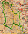 Click ^ Much of the route has the flavour of the Rocky Mountain 1200 with those characteristically chiseled peaks and ranges. But I saw ten times as much wildlife on this route as on Rocky 2002. The route also covers the ranchlands of Alberta's Rocky Mountain foothills, a lovely out and back leg to Elkford, Crowsnest pass and the Frank slide, and a picturesque run alongside Columbia Lake en route back in from Radium Hot Springs to Cranbrook. Mind you, the ending's a bit of a bitch. To make up a very slight distance shortfall, the route finishes by taking the western diversion of highway 93 at 956 km, which includes a nasty climb up through Kimberley - apparently the highest elevation city in Canada at 1113m.* Still, this route's a keeper - mark it in down your long range planner. June 24, 2004 *Note: Banff (1383m.) and Lake Louise (1536m.) are higher, but are not "cities". |
